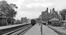
Brecon Free Street railway station
| Brecon Free Street railway station | |
|---|---|

View westward, towards Neath. Shortly before closure in 1962
|
|
| Location | |
| Place | Brecon |
| Area | Powys |
| Coordinates | 51°56′47″N 3°23′05″W / 51.9463°N 3.3846°WCoordinates: 51°56′47″N 3°23′05″W / 51.9463°N 3.3846°W |
| Grid reference | SO049284 |
| Operations | |
| Original company | Brecon and Merthyr Tydfil Junction Railway |
| Pre-grouping | Brecon and Merthyr Tydfil Junction Railway |
| Post-grouping | Great Western Railway |
| History | |
| 1 March 1871 | Joint station opens |
| 31 December 1962 | Station closes to passengers |
| 4 May 1964 | Station closes to goods |
| Disused railway stations in the United Kingdom | |
| Closed railway stations in Britain A B C D–F G H–J K–L M–O P–R S T–V W–Z |
|
|
|
|
Brecon Free Street railway station served Brecon, in the historic Welsh county of Brecknockshire, now Powys.
The Brecon and Merthyr Railway opened its first station in Watton in 1863. The Neath and Brecon Railway had a temporary station at Brecon Mount Street by 1868, but a joint station was opened at Free Street in 1871.
The line and station finally closed in 1964.
The Brecon and Merthyr Tydfil Junction Railway obtained an Act of Parliament on 1 August 1859 to construct a line between Talybont and Pant. Train services between Brecon and Pant officially began on 23 April 1863 but two trains per day ran from 19 March 1863.
It became part of the Great Western Railway during the Grouping of 1923.
A special train ran to Free Street on 2 May 1964 named the Last Train to Brecon.
The line closed to passengers on 31 December 1962 and to goods on 4 May 1964.
Heol Gouesnou approximately follows the course of the railway from The Struet to the site of Brecon Free Street station (near the bus station).
...
Wikipedia
