Bravoniacum
| Kirkby Thore | |
|---|---|
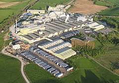
 Kirkby Thore Gypsum Plant |
|
| Kirkby Thore shown within Cumbria | |
| Population | 758 (2011) |
| OS grid reference | NY639257 |
| Civil parish |
|
| District | |
| Shire county | |
| Region | |
| Country | England |
| Sovereign state | United Kingdom |
| Post town | PENRITH |
| Postcode district | CA10 |
| Dialling code | 017683 |
| Police | Cumbria |
| Fire | Cumbria |
| Ambulance | North West |
| EU Parliament | North West England |
| UK Parliament | |
Kirkby Thore is a small village, civil parish and hill in Cumbria, England at grid reference NY639257. It is close to the Lake District national park and the Cumbrian Pennines. The market town of Appleby-in-Westmorland is about 5 miles away, and the larger town of Penrith is about 8 miles away. As this suggests, it is in the historic county of Westmorland.
The place-name 'Kirkby Thore' is first attested in 1179 in the 'Register of Holm Cultram', where it appears as Kirkebythore. Kirkby means 'church village' or 'village with a church', whilst Thore is an Old Norse personal name related to the god Thor.
The village is on the site of a Roman cavalry camp called Bravoniacum or Brovonacae and Roman coins, tombstones, sandals, urns, earthen vessels, and the cusp of a spear have been found in the locality. The Maiden Way Roman road led north from Bravoniacum to Epiacum (Whitley Castle), and thence to Magnae (Carvoran) on Hadrian's Wall, where it joined the Stanegate road running from west to east. A continuation from there ran east to Banna (Birdoswald) and then 7 mi (11 km) north to the Shrine of Cocidius (Bewcastle). LIDAR technology has recently revealed another Roman road running southwest from Kirkby Thore to the Roman fort at Low Borrowbridge near Tebay.
...
Wikipedia

