Brass River
| Brass River | |
|---|---|

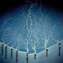
2005 satellite view of Niger Delta. Brass River to the right
|
|

|
|
| Country | Nigeria |
| Basin features | |
| Main source | 4°56′40″N 6°15′02″E / 4.944439°N 6.250647°E |
| River mouth | 4°19′03″N 6°13′27″E / 4.317373°N 6.224294°ECoordinates: 4°19′03″N 6°13′27″E / 4.317373°N 6.224294°E |
| Physical characteristics | |
| Length | 161 km (100 mi) |
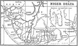
The Brass River is one of the branches of the Nun River, which in turn is a branch of the Niger River, in the Niger Delta in Nigeria. In the 19th century the river was an important trading route, first for slaves and later for palm oil. Brass River Crude Oil is named for a refinery on the river.
The name "Brass" is European, said to have been given to the Nembe coastal villages because they traded for brass pans and neptunes to use for salt boiling. The "Brass Ijo" were all the Ijaw people from Cape Formosa to the Santa Barbara River. The name was used specifically for Twon village on the Brass river, the route to the Nembe capital in the interior. In the 1884 and 1886 treaties "Brass" referred to the Nembe state. The Brass river was also called the Rio Bento, or St. John river.
The Brass River is a branch, or distributary, of the Nun River, which flows to the west. The Nun River is itself a continuation of the Niger River, which divides into the Nun and Forçados Rivers about 32 kilometres (20 mi) downstream from Aboh. The Brass leaves the east side of the Nun at Yenagoa and flows south to discharge into the Gulf of Guinea. The tidal flats of the river have a reticulate drainage pattern, with higher elevation at the edges of the flats than at the center. Discharge varies depending on the season and state of the tide:
An 1893 navigation guide says of the river,
The entrance is 3⁄4 mile wide, and lies between two points, which, when the entrance bears N.7° E. (N. 23° E. mag.), appear well defined, the trees on the western point being more rugged and lower than those on the eastern point, Within the entrance points, the river expands to 2 miles in width abreast the factories, which breadth it maintains as far as Opulobo or Big island, lying nearly in the middle of the river, 4 miles from the entrance.
The mouth of the river is protected by a sand bar, which in 1893 could not be crossed by vessels with more than 16 feet (4.9 m) draft. Akassa creek, 1.5 miles (2.4 km) inland from the mouth of the river, provided a route from the Brass river to the Nun river for vessels of 7 feet (2.1 m) draft. It was often used by merchant steamers trading on the Niger, since the entrance of the Brass was easier than that of the Nun. Many factories lay on the east shore of the Brass just inside the entrance, handling the extensive trade in palm oil and ivory. At that time Akedo, about 26 miles (42 km) above cape Nun, was the market place for traders from the Brass river.
...
Wikipedia
