Branston, Leicestershire
| Branston | |
|---|---|
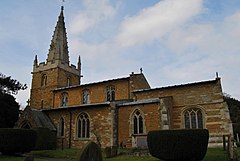
 St Guthlac's Church, Branston |
|
| Branston shown within Leicestershire | |
| OS grid reference | SK810293 |
| • London | 95 mi (153 km) S |
| District | |
| Shire county | |
| Region | |
| Country | England |
| Sovereign state | United Kingdom |
| Post town | GRANTHAM |
| Postcode district | NG32 |
| Dialling code | 01476 |
| Police | Leicestershire |
| Fire | Leicestershire |
| Ambulance | East Midlands |
| EU Parliament | East Midlands |
| UK Parliament | |
Branston is a village in the civil parish of Croxton Kerrial and Branston, in Leicestershire, England. It is geographically situated 1 mile (1.6 km) north from the A607 road, 7 miles (11 km) south-west from Grantham and 7 miles north-east from Melton Mowbray. The village is at the southern edge of the Vale of Belvoir, and 3 miles (5 km) south-west from Belvoir Castle. Knipton Reservoir is 700 yards (640 m) to the north. The population is included in the civil parish of Croxton Kerrial.
According to A Dictionary of British Place Names, Branston could be "a farmstead or a village of a man called Brant" – 'Brant' from an Old English person name and 'ton' for "enclosure, farmstead, village, manor, [or] estate".
In the 1086 Domesday account Branston is referred to as "Brantestone" in the Framland Hundred of north-east Leicestershire. It had 21 households, 10 villagers, 1 smallholder 6 freemen and 4 slaves, with a meadow of 16 acres (0.1 km2) and 2 mills. In 1066 Leofnoth of Branston was Lord of the Manor; after 1086 this transferred to Ralph of Kimcote, with the Bishop of Lincoln becoming Tenant-in-chief.
The Grade II* listed Anglican parish church is dedicated to St Guthlac, originating in the 13th century with alterations up the 15th. New chancel and nave roofs were added in 1895-96 by George Frederick Bodley and Thomas Garner, Gothic Revival architects. Further Grade II listed buildings are three 18th-century farmhouses, the early 19th-century Old Rectory, and the Village Hall dating from 1843.
...
Wikipedia

