Branford, FL
| Branford, Florida | |
|---|---|
| Town | |

Branford Town Hall
|
|
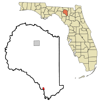
 Location in Suwannee County and the state of Florida |
|
| Coordinates: 29°57′42″N 82°55′38″W / 29.96167°N 82.92722°WCoordinates: 29°57′42″N 82°55′38″W / 29.96167°N 82.92722°W | |
| Country | United States |
| State | Florida |
| County | Suwannee |
| Area | |
| • Total | 0.8 sq mi (2.1 km2) |
| • Land | 0.8 sq mi (2.1 km2) |
| • Water | 0 sq mi (0 km2) |
| Elevation | 43 ft (13 m) |
| Population (2016) | |
| • Total | 721 |
| • Density | 890/sq mi (339/km2) |
| Time zone | Eastern (EST) (UTC-5) |
| • Summer (DST) | EDT (UTC-4) |
| ZIP code | 32008 |
| Area code(s) | 386 |
| FIPS code | 12-08175 |
| GNIS feature ID | 0279335 |
Branford is a town in Suwannee County, Florida, United States. The population was 712 at the 2010 census.
Branford is located at 29°57′42″N 82°55′38″W / 29.96167°N 82.92722°W (29.961803, -82.927204).
The town is located on the banks of the Suwannee River. U.S. Route 27 and U.S. Highway 129 intersect in Branford.
According to the United States Census Bureau, the town has a total area of 0.8 square miles (2.1 km2), all land.
Branford is located (depending on the route of travel) approximately:
As of the census of 2010, there were 712 people, 277 households, and 185 families residing in the town. The population density was 890 people per square mile (323.3/km²). There were 347 housing units at an average density of 386.1 per square mile (148.9/km²). The racial makeup of the town was 80.2% White, 6.9% African American, 0.8% Native American, 1.7% Asian, Hispanic or Latino of any race were 13.2% of the population.
...
Wikipedia
