Braintree, England
| Braintree | |
|---|---|
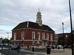
 Braintree Town Hall Centre in 2005 |
|
| Braintree shown within Essex | |
| Population | 53,477 (2011) |
| OS grid reference | TL7522 |
| District | |
| Shire county | |
| Region | |
| Country | England |
| Sovereign state | United Kingdom |
| Post town | BRAINTREE |
| Postcode district | CM7, CM77 |
| Dialling code | 01376 |
| Police | Essex |
| Fire | Essex |
| Ambulance | East of England |
| EU Parliament | East of England |
| UK Parliament | |
Braintree is a town in Essex, England. The principal settlement of Braintree District, it is located 10 miles (16 km) northeast of Chelmsford and 15 miles (24 km) west of Colchester. According to the 2011 Census, the town had a population of 41,634, while the urban area, which includes Great Notley, Rayne and High Garrett, had a population of 53,477.
Braintree has grown contiguous with several surrounding settlements. Braintree proper lies on the River Brain and to the south of Stane Street, the Roman road from Braughing to Colchester, while Bocking lies on the River Blackwater and to the north of the road. The two are sometimes referred to together as Braintree and Bocking, and since 1934 they form the civil parish of that name.
Braintree is bypassed by the modern-day A120 and A131 roads, while trains serve two stations in the town, at the end of the Braintree Branch Line.
Braintree is twinned with Pierrefitte-sur-Seine, France, and gives its name to the towns of Braintree, Massachusetts and Braintree, Vermont, in the United States.
The origin of the name Braintree is obscure. Braintree, Essex was also called Brantry and Branchetreu in the Domesday Book. Another variation can be seen in various Medieval Latin legal records, where it appears as "Branktre". In many early American Colonial documents, it is referred to as Branktry.
...
Wikipedia

