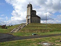
Bracebridge Heath
| Bracebridge Heath | |
|---|---|
 Bracebridge Heath Reservoir |
|
| Bracebridge Heath shown within Lincolnshire | |
| Population | 5,656 (2011) |
| OS grid reference | SK978670 |
| • London | 115 mi (185 km) S |
| Shire county | |
| Region | |
| Country | England |
| Sovereign state | United Kingdom |
| Post town | Lincoln |
| Postcode district | LN4 |
| Dialling code | 01522 |
| Police | Lincolnshire |
| Fire | Lincolnshire |
| Ambulance | East Midlands |
| EU Parliament | East Midlands |
| UK Parliament | |
Bracebridge Heath is a commuter village located approximately 2 miles (3 km) south from the city and county town of Lincoln, England. It lies at the junction of two major roads the A15 to Sleaford and the A607 to Grantham, and was (until modern systems of local government were introduced in the 19th century) part of the Boothby Graffoe Wapentake. The village sits on top of Lincoln Cliff, overlooking Lincoln and the valley of the River Witham. The Viking Way runs along the cliff top, a 147 miles (237 km) long footpath, which runs from the Humber Bridge to Oakham. Its population at the 2001 census was 4,530, increasing to 5,656 at the 2011 census.
Until 1898 Bracebridge Heath was part of the parish of Bracebridge. Bracebridge may have had its origins in the Old English braesc + brycg, meaning 'bridge or causeway made of branches'. The River Witham runs 1 mile (1.6 km) to the west, lending some credibility to this theory.
The village is mentioned in the Domesday Book as "Brachebrige". Before the Norman Conquest lordship was held by Ulf Fenman, and after by Bishop Geoffrey of Coutances, who also became Tenant-in-chief.
Bracebridge Heath lies on the route of the Roman Ermine Street that runs approximately 200 miles (320 km) from London to York. The central road junction in Bracebridge Heath is the junction of three Roman roads, now the A15 (the Sleaford Road), the A607 (the Grantham Road), and Cross O'Cliffe Hill into Lincoln. The line of Ermine Street, when extended from its last traceable part at Harmston, south of Bracebridge Heath, runs north through Waddington to Heath Road in Bracebridge Heath. Heath Road continues the line of Ermine Street.
...
Wikipedia

