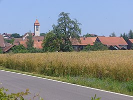
Brütten
| Brütten | ||
|---|---|---|
 |
||
|
||
| Coordinates: 47°28′N 8°40′E / 47.467°N 8.667°ECoordinates: 47°28′N 8°40′E / 47.467°N 8.667°E | ||
| Country | Switzerland | |
| Canton | Zurich | |
| District | Winterthur | |
| Area | ||
| • Total | 6.61 km2 (2.55 sq mi) | |
| Elevation | 610 m (2,000 ft) | |
| Population (Dec 2016) | ||
| • Total | 2,021 | |
| • Density | 310/km2 (790/sq mi) | |
| Postal code | 8311 | |
| SFOS number | 0213 | |
| Localities | Straubikon | |
| Surrounded by | Lindau, Nürensdorf, Oberembrach, Winterthur | |
| Website |
www SFSO statistics |
|
Brütten is a municipality in the district of Winterthur, in the Canton of Zürich, Switzerland.
Brütten is first mentioned in 876 as Pritta.
Brütten has an area of 6.7 km2 (2.6 sq mi). Of this area, 58.9% is used for agricultural purposes, while 30.1% is forested. The rest of the land, (11%) is settled. In 1996[update] housing and buildings made up 6.1% of the total area, while transportation infrastructure made up the rest (4.6%). As of 2007[update] 7.2% of the total municipal area was undergoing some type of construction.
The municipality is located on a high plateau west of the Kempt and Töss Valleys. It includes the village of Brütten along with the hamlets of Strubikon, Birch, Eich and since 1922 Obereich.
Brütten has a population (as of 31 December 2016) of 2,021. As of 2007[update], 5.7% of the population was made up of foreign nationals. As of 2008[update] the gender distribution of the population was 50.5% male and 49.5% female. Over the last 10 years the population has grown at a rate of 9.7%. Most of the population (as of 2000[update]) speaks German (95.1%), with English being second most common ( 1.3%) and French being third ( 1.1%).
In the 2007 election the most popular party was the SVP which received 36.2% of the vote. The next three most popular parties were the FDP (16.7%), the SPS (12.7%) and the CSP (11.7%).
...
Wikipedia


