Boxford, Massachusetts
| Boxford, Massachusetts | ||
|---|---|---|
| Town | ||

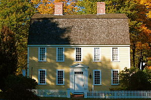
The Holyoke-French House (c. 1760) in East Boxford Village
|
||
|
||
 Location in Essex County and the state of Massachusetts. |
||
| Coordinates: 42°39′40″N 70°59′50″W / 42.66111°N 70.99722°WCoordinates: 42°39′40″N 70°59′50″W / 42.66111°N 70.99722°W | ||
| Country | United States | |
| State | Massachusetts | |
| County | Essex | |
| Settled | 1645 | |
| Incorporated | 1685 | |
| Government | ||
| • Type | Open town meeting | |
| Area | ||
| • Total | 24.4 sq mi (63.2 km2) | |
| • Land | 23.6 sq mi (61.0 km2) | |
| • Water | 0.8 sq mi (2.2 km2) | |
| Elevation | 95 ft (29 m) | |
| Population (2010) | ||
| • Total | 7,965 | |
| • Density | 330/sq mi (130/km2) | |
| Time zone | Eastern (UTC-5) | |
| • Summer (DST) | Eastern (UTC-4) | |
| ZIP code | 01921 | |
| Area code(s) | 351 / 978 | |
| FIPS code | 25-07420 | |
| GNIS feature ID | 0618294 | |
| Website | Town of Boxford Official Web Site | |
Boxford is a town in Essex County, Massachusetts, United States. According to the U.S. Census Bureau, the town's population in 2010 was 7,965.
The original town center of Boxford, was East Boxford and other areas in the eastern part of the town, comprise the census-designated place of Boxford.
Boxford was first settled in 1646 as a part of Rowley Village by Abraham Redington. When it was officially incorporated in 1685, about forty families resided in Boxford. Farming was the primary occupation of the early settlers although craftsmen were also found among the townspeople. The largest industry in Boxford was the match factory (located on Lawrence Road) which operated from 1866 to 1905. The original building of the First Church was built in 1701 in East Boxford Village. As the population of West Boxford expanded, the legislature designated this section as precinct 2 in 1735. Town meetings alternated between East and West parishes. The first West Boxford church building was erected in 1774.
According to the United States Census Bureau, the town has a total area of 24.4 square miles (63.2 km2), of which 23.6 square miles (61.0 km2) is land and 0.85 square miles (2.2 km2), or 3.46%, is water.
Boxford is divided into Boxford Village (commonly called East Boxford) and West Boxford Village, corresponding to the respective East and West Boxford centers. It is heavily forested and criss-crossed by various streams and brooks, many of which empty into the Ipswich River on Boxford's southern border. A number of ponds dot town as well, among them Stiles Pond, Cedar Pond, Spofford Pond, Lowe Pond, Four Mile Pond and Baldpate Pond. Throughout Boxford there are also a number of scenic hiking trails. The highest natural point in Boxford is Bald Hill, at an elevation of 243 feet (74 m). It sits in a corner of the Boxford State Forest, near Interstate 95 and the town's border with Middleton.
Small farms are interspersed throughout Boxford. Stone walls, remnants of old farming land boundaries, meander through the area. One major farm located in Boxford is Small Oxx farm, a branch of the main farm, Smolak's, located in North Andover.
...
Wikipedia

