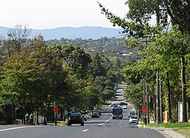
Box Hill South, Victoria
|
Box Hill South Melbourne, Victoria |
|||||||||||||
|---|---|---|---|---|---|---|---|---|---|---|---|---|---|

Riversdale Road
|
|||||||||||||
| Coordinates | 37°50′10″S 145°07′26″E / 37.836°S 145.124°ECoordinates: 37°50′10″S 145°07′26″E / 37.836°S 145.124°E | ||||||||||||
| Population | 7,699 (2011 census) | ||||||||||||
| • Density | 2,200/km2 (5,700/sq mi) | ||||||||||||
| Postcode(s) | 3128 | ||||||||||||
| Area | 3.5 km2 (1.4 sq mi) | ||||||||||||
| Location | 14 km (9 mi) from Melbourne | ||||||||||||
| LGA(s) | City of Whitehorse | ||||||||||||
| State electorate(s) | Burwood | ||||||||||||
| Federal Division(s) | Chisholm | ||||||||||||
|
|||||||||||||
Box Hill South is a suburb of Melbourne, Victoria, Australia, 14 km east of Melbourne's Central Business District. Its local government area is the City of Whitehorse. At the 2011 Census, Box Hill South had a population of 7,699.
In the summer of 1885/86, Tom Roberts and Frederick McCubbin set up a camp, on a site near Damper Creek (now Gardiners Creek), on the property of David Houston, about a mile south of the Box Hill railway station. In this location, painting activities were carried out on weekends over the next few years. At this time the area was relatively untouched bushland.
Following the end of World War II, extensive suburbanisation of the area occurred, including the development of a Housing Commission estate.
Box Hill South Post Office opened on 19 October 1927, with the Wattle Park Post Office opening on 12 December 1960 and the Houston Post Office, on Middleborough Road, on 16 October 1961.
Heritage places listed in the City of Whitehorse Planning Scheme include Tyneholm, in Elgar Road (built in 1891), Pound House in Canterbury Road, St James Uniting Church in Riversdale Road and Gwynton Park (built c. 1907), which is now the administration building of Kingswood College in Station Street.
Box Hill South is bounded to the north by Canterbury Road, to the east by Middleborough Road, to the south by the Burwood campus of Deakin University, Gardiners Creek and Eley Road and to the west by Elgar Road. Gardiners Creek runs diagonally across the suburb from the north-east to the south-west.
...
Wikipedia

