Bourke, NSW
|
Bourke New South Wales |
|||||||||
|---|---|---|---|---|---|---|---|---|---|

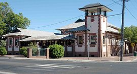
Court house
|
|||||||||
| Coordinates | 30°06′0″S 145°56′0″E / 30.10000°S 145.93333°ECoordinates: 30°06′0″S 145°56′0″E / 30.10000°S 145.93333°E | ||||||||
| Population | 2,047 (2011 census) | ||||||||
| Postcode(s) | 2840 | ||||||||
| Elevation | 106 m (348 ft) | ||||||||
| Location |
|
||||||||
| LGA(s) | Bourke Shire | ||||||||
| State electorate(s) | Barwon | ||||||||
| Federal Division(s) | Parkes | ||||||||
|
|||||||||
Bourke is a town in the north-west of New South Wales, Australia. The administrative centre and largest town in Bourke Shire, Bourke is approximately 800 kilometres (500 mi) north-west of the state capital, Sydney, on the south bank of the Darling River. At the 2011 census, Bourke had a population of 2,047, of whom 762 (or 37%) identified as Indigenous Australians.
The location of the current township of Bourke on a bend in the Darling River is the traditional country of the Ngemba people.
The first white explorer to encounter the river was Charles Sturt in 1828 who named it after New South Wales Governor Ralph Darling. Having struck the region during an intense drought and a low river, Sturt dismissed the area as largely uninhabitable and short of any features necessary for establishing renewable industry on the land.
It was not until the mid-1800s following a visit by colonial surveyor and explorer Sir Thomas Mitchell in 1835 that settlement of the area began. Following tensions with the local people Mitchell built a small stockade to protect his men and named it Fort Bourke after then Governor Richard Bourke. This first crude structure became the foundation for a fledgling community with a small number of agricultural and livestock farms established in the region shortly afterwards. The area started to flourish when its location on the Darling River had it recognised as a key trade centre, linking the nearby outback agricultural industries with the east coast trade routes via the Darling River.
Bourke was surveyed for a town in 1869 and soon established itself as the outback trade hub of New South Wales with several transportation industries setting up branches in the town. By the 1880s Bourke would host a Cobb & Co. Coach Terminus, several paddle boat companies running the Darling and a bridge crossing the river that would allow for road transportation into the town and by 1885 Bourke would be accessible by rail, confirming its position as a major inland transport hub. Like many outback Australian townships, Bourke would come to rely on camels for overland transport, and the area supported a large Afghan community that had been imported to drive the teams of camels. A small Afghan mosque that dates back to the 1900s can be found within Bourke cemetery.
...
Wikipedia

