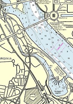
Boundary Channel
| Boundary Channel | |
| Channel | |
|
Map of area surrounding Boundary Channel and the Pentagon Lagoon
|
|
| Country | United States |
|---|---|
| State | District of Columbia |
| Part of | Potomac River |
| Source | Potomac River |
| - elevation | 0 ft (0 m) |
| - coordinates | 38°53′24.4″N 77°3′49.3″W / 38.890111°N 77.063694°W |
| Mouth | Pentagon Lagoon |
| - elevation | 0 ft (0 m) |
| - coordinates | 38°52′26″N 77°2′53″W / 38.87389°N 77.04806°WCoordinates: 38°52′26″N 77°2′53″W / 38.87389°N 77.04806°W |
Boundary Channel is a channel off the Potomac River in Washington, D.C. The channel begins at the northwestern tip of Columbia Island extends southward between Columbia Island and the Virginia shoreline. It curves around the southern tip of Columbia Island before heading northeast to exit into the Potomac River. At the southwestern tip of Columbia Island, the Boundary Channel widens into the manmade Pentagon Lagoon.
Columbia Island is in part natural, and in part man-made. About 1818, Analostan Island (now known as Theodore Roosevelt Island) was largely rock and quite close to the D.C. shoreline. Due to deforestation and increased agricultural use upstream, the river eroded much of the northern bank of the Potomac River and widened the gap between Analostan Island and the shore. Simultaneously, large deposits of silt built up around Analostan Island. By 1838, Analostan had almost doubled in length toward the south. By 1884, the new southern part of Analostan Island was defined and built up, and supported a well-established wetland. Gradually, however, the river eroded the center of Analostan Island, severing Columbia Island from its parent body.
Between 1911 and 1922, the Potomac River was repeatedly dredged by the United States Army Corps of Engineers to deepen the channel and alleviate flooding. Dredging widened the distance between Analostan/Theodore Roosevelt Island and Columbia Island (so that the "Virginia Channel" west of Analostan/Roosevelt Island would not flood easily). Dredged material was piled high on Columbia Island, helping to build it higher, lengthen and broaden it, and give it its current shape. The new island received its name about 1918 from an unnamed engineer working for the District of Columbia.
An anonymous Corps of Engineers officer named the waterway between Columbia Island and Virginia the "Boundary Channel".
Boundary Channel was further defined in the late 1920s. In 1925, Congress authorized construction of the Arlington Memorial Bridge across the Potomac River. Preliminary designs for the bridge showed it terminating on Columbia Island, which necessitated additional expansion of the island. The Corps of Engineers had already planned to continue dredging the Potomac River and enlarge Columbia Island, so on April 1, 1925, Secretary of War John W. Weeks ordered the expenditure of $114,500 to dredge the river between the Highway Bridge and the Lincoln Memorial. The dredged material was dumped on Columbia Island. By June 30, 1927, dredging of the Potomac River and the reshaping of Columbia Island was largely finished.
...
Wikipedia

