Boroondara City Council
|
City of Boroondara Victoria |
|||||||||||||||
|---|---|---|---|---|---|---|---|---|---|---|---|---|---|---|---|

City of Harmony
|
|||||||||||||||
| Population | 167,231 (2016 census) (31st) | ||||||||||||||
| • Density | 2,790/km2 (7,200/sq mi) | ||||||||||||||
| Established | 1994 | ||||||||||||||
| Area | 60 km2 (23.2 sq mi) | ||||||||||||||
| Mayor | Jim Parke | ||||||||||||||
| Council seat | Camberwell | ||||||||||||||
| Region | Inner eastern metropolitan Melbourne | ||||||||||||||
| State electorate(s) | |||||||||||||||
| Federal Division(s) | |||||||||||||||
 |
|||||||||||||||
| Website | City of Boroondara | ||||||||||||||
|
|||||||||||||||
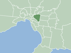
The City of Boroondara (/ˈbɒrʊndərə/) is a local government area in Victoria, Australia. It is located in the eastern suburbs of Melbourne. It was formed in June 1994 from the amalgamation of the Cities of Kew, Camberwell and Hawthorn.
It has an area of 60 square kilometres (23 sq mi). At the 2016 Census the City had a population of 167,231. Boroondara was rated ninth of 590 Australian local government areas in the BankWest Quality of Life Index 2008, and first in a 2013 Victoria-wide community satisfaction survey.
This area was originally occupied by the Wurundjeri Indigenous Australians of the Kulin nation.
In 1837, John Gardiner (after whom Gardiners Creek was named) and his family were the first Europeans to settle in the area. Robert Hoddle surveyed the area in 1837 and declared it the "Parish of Boroondara". The area was densely wooded, so he took a word from the Woiwurrung language (as spoken by the Wurundjeri), meaning "where the ground is thickly shaded".
The first Local Government body was the Boroondara District Road Board, formed on 11 July 1854 and incorporating the areas which were to become the City of Hawthorn, City of Kew and City of Camberwell. Hawthorn and Kew were created as separate municipalities in 1860 and the remaining area of the Road Board became Shire of Boroondara on 17 November 1871, which later became the City of Camberwell.
...
Wikipedia
