Bordertown, South Australia
|
Bordertown South Australia |
|||||||||||||
|---|---|---|---|---|---|---|---|---|---|---|---|---|---|

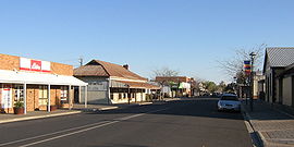
Main street in Bordertown
|
|||||||||||||
| Coordinates | 36°18′0″S 140°46′0″E / 36.30000°S 140.76667°ECoordinates: 36°18′0″S 140°46′0″E / 36.30000°S 140.76667°E | ||||||||||||
| Population | 2,581 (2006 census) | ||||||||||||
| Established | 1852 | ||||||||||||
| Postcode(s) | 5268 | ||||||||||||
| Location | |||||||||||||
| LGA(s) | Tatiara District Council | ||||||||||||
| State electorate(s) | MacKillop | ||||||||||||
| Federal Division(s) | Barker | ||||||||||||
|
|||||||||||||
Bordertown is a small South Australian town near the Victorian border. It is where the Dukes Highway and the railway line, the two main routes between Adelaide and Melbourne, cross Tatiara Creek.
Bordertown is the commercial and administrative centre of the Tatiara District Council. Tatiara is the local Aboriginal word for "Good Country". Bordertown was established in 1852 when a direct route across the 90-mile desert was being planned for gold escorts from the Victorian goldfields to Adelaide. Police Inspector Alexander Tolmer was instructed to create a town as close as practical to the border. Tolmer was upset when the town was not named after him, but that was made up for by naming several sites around Bordertown after him, such as Tolmer Park and Tolmer Takeaway. Bordertown is also the birthplace of former Prime Minister of Australia, Bob Hawke.
Bordertown is the seat of the Tatiara District Council. It is in the state electoral district of MacKillop and the federal Division of Barker. It is the birthplace of former Prime Minister of Australia, Bob Hawke.
Bordertown is home to the historic Clayton Farm Heritage Museum. It is also famous for its white Kangaroos which have been bred for zoos and animal shelters around Australia. The lightning clock on the main street marks the site of the first electricity source.
...
Wikipedia

