Bongabon, Nueva Ecija
| Bongabon | ||
|---|---|---|
| Municipality | ||

Municipal hall of Bongabon
|
||
|
||
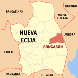
 Map of Nueva Ecija showing the location of Bongabon |
||
| Location within the Philippines | ||
| Coordinates: 15°37′52″N 121°08′38″E / 15.63111°N 121.14389°ECoordinates: 15°37′52″N 121°08′38″E / 15.63111°N 121.14389°E | ||
| Country | Philippines | |
| Region | Central Luzon (Region III) | |
| Province | Nueva Ecija | |
| District | 3rd District | |
| Founded | 1760 | |
| Barangays | 28 | |
| Government | ||
| • Mayor | Ricardo Padilla | |
| Area | ||
| • Total | 286.95 km2 (110.79 sq mi) | |
| Population (2010) | ||
| • Total | 59,343 | |
| • Density | 210/km2 (540/sq mi) | |
| Time zone | PST (UTC+8) | |
| ZIP code | 3128 | |
| IDD : area code | +63 (0)44 | |
| Income class | 2nd class | |
| Website | www |
|
Bongabon is a second class municipality in the province of Nueva Ecija, Philippines. According to the 2010 census, it had a population of 59,343 people. It has an area of 28,352.90 hectares (70,061.5 acres), and is the leading producer of onion in the Philippines and in Southeast Asia.
Each barangay in Bongabon has its own fiesta. The town fiesta, celebrated annually on the 1st to 2nd week of April, is known as the Sibuyasan Onion Festival.
Bongabon is politically subdivided into 28 barangays, listed here with their 2010 populations:
Poblacion barangays:
Rural barangays:
The Augustinian missionaries who preached Catholicism in Pampanga extended their outposts into what is now the province of Nueva Ecija by following the Rio Grande dela Pampanga. Thus, Santol (present day Barangay Santor) was part of Pantabangan and established in 1659. In 1760, Bongabon was named as a town and parish under the patronage of St. Francis of Assisi.
Bongabon was the first capital of Nueva Ecija.
When the Philippine Revolution began on 1896 to 1898 against Spain. The Philippine Revolutionary and Republican troops with the aid of Katipunero rebels invaded the municipal town of Bongabon and fought the Spanish Colonial forces and started the Siege of Bongabon. The Filipino revolutionary troops and Katipunero rebel fighters captured the municipal town after the siege forcing the Spanish troops to retreat.
With the outbreak of the Philippine–American War on 1899 to 1902, the town saw the arrival of American troops which fought the Filipino revolutionary troops and Katipuneros in the Battle of Bongabon on 1899. In the ensuing battle, the town was captured by the American troops.
The outbreak was start the Second World War, Japanese planes was crushed to invaded the town municipality in Bongabon on December 1941 under the Japanese Invasion and through the occupied by the Imperial Japanese forces was entering the town on 1942 and begins the Japanese Occupation. The active of the general headquarters and garrison bases of the Imperial Japanese Armed Forces was established on 1942 through the combined Allied United States and the Philippine Commonwealth military and recognized guerrilla raid and captured on 1945 and they stationed in the municipality of Bongabon during the Japanese Occupation.
...
Wikipedia


