Boma, Kongo Central
| Boma | |
|---|---|

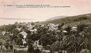
View of Boma in c.1900
|
|
| Location in Democratic Republic of the Congo | |
| Coordinates: 5°51′S 13°03′E / 5.850°S 13.050°E | |
| Country |
|
| Province | Kongo Central |
| Area | |
| • Total | 65 km2 (25 sq mi) |
| Elevation | 61 m (200 ft) |
| Population (2012) | |
| • Total | 162,521 |
| • Density | 2,500/km2 (6,500/sq mi) |
Boma is a port town on the Congo River, some 100 km upstream from the Atlantic Ocean, in the Kongo Central province of the Democratic Republic of the Congo. It had an estimated population of 162,521 in 2012.
Boma was the capital city of the Congo Free State and Belgian Congo (the modern Democratic Republic of the Congo) from 1 May 1886 to 1926, when the capital was moved to Léopoldville (since renamed Kinshasa). The port handles exports of tropical timber, bananas, cacao, and palm products.
Boma was founded as a slaving station and entrepôt by merchants of several European countries in the 16th century. Trade was chiefly in the hands of Dutch merchants, but British, French and Portuguese firms also had factories there. No European power exercised sovereignty, though claims were from time to time put forward by Portugal.
Henry Morton Stanley arrived here on 9 Aug. 1877, after crossing Africa east to west.
In 1884 the people of Boma 'granted' a protectorate of their country to the International Association of the Congo.
Boma lies on the north bank of the Congo River, some 100 km upstream from Muanda, where the river meets the Atlantic Ocean. The great width and depth of the river allow seagoing ships to reach Boma, which is the second-largest port of DR Congo, after Matadi. Between 1889 and 1984, the port was served by a 610 mm gauge railway line from Tshela.
...
Wikipedia

