Boligee, Alabama
| Boligee, Alabama | |
|---|---|
| Town | |

The U.S. Post Office in Boligee, Alabama
|
|
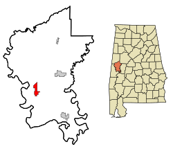
 Location in Greene County and the state of Alabama |
|
| Coordinates: 32°45′49″N 88°1′33″W / 32.76361°N 88.02583°W | |
| Country | United States |
| State | Alabama |
| County | Greene |
| Area | |
| • Total | 4 sq mi (10.2 km2) |
| • Land | 4 sq mi (10.2 km2) |
| • Water | 0 sq mi (0 km2) |
| Elevation | 121 ft (37 m) |
| Population (2010) | |
| • Total | 328 |
| • Density | 83/sq mi (32.1/km2) |
| Time zone | Central (CST) (UTC-6) |
| • Summer (DST) | CDT (UTC-5) |
| ZIP code | 35443 |
| Area code(s) | 205 |
| FIPS code | 01-08104 |
| GNIS feature ID | 0114691 |
Boligee is a town in Greene County, Alabama, United States. At the 2010 census the population was 328, down from 369 in 2000. Although Boligee appeared on the 1880 U.S. Census, according to the 1930 U.S. Census it did not incorporate until 1926, though another source cited 1927.
Boligee has one site listed on the National Register of Historic Places, Boligee Hill.
Boligee is located at 32°45′50″N 88°1′33″W / 32.76389°N 88.02583°W (32.763768, -88.025968).
According to the U.S. Census Bureau, the town has a total area of 4.0 square miles (10 km2), all land.
As of the census of 2000, there were 369 people, 150 households, and 105 families residing in the town. The population density was 93.3 people per square mile (36.0/km2). There were 179 housing units at an average density of 45.2 per square mile (17.5/km2). The racial makeup of the town was 10.57% White, 88.89% Black or African American, and 0.54% from two or more races. 1.90% of the population were Hispanic or Latino of any race.
...
Wikipedia
