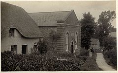
Blunsdon
| Blunsdon | |
|---|---|
 Chapel Hill, Blunsdon ca.1920 |
|
| Blunsdon shown within Wiltshire | |
| Population | 12,414 (parish, 2011) |
| OS grid reference | SU154902 |
| Civil parish |
|
| Unitary authority | |
| Ceremonial county | |
| Region | |
| Country | England |
| Sovereign state | United Kingdom |
| Post town | Swindon |
| Postcode district | SN25, SN26 |
| Dialling code | 01793 |
| Police | Wiltshire |
| Fire | Dorset and Wiltshire |
| Ambulance | South Western |
| EU Parliament | South West England |
| UK Parliament | |
| Website | Blunsdon St Andrew Parish Council |
Broad Blunsdon is a village in the Borough of Swindon, England, about 4 miles (6 km) north of the centre of Swindon. Together with the nearby villages of Blunsdon St Andrew and adjoining Lower Blunsdon, the area is usually known simply as Blunsdon. The hamlet of Broadbush is now contiguous with Broad Blunsdon. The A419 dual carriageway divides the area into Blunsdon St Andrew to the west and Broad Blunsdon to the east.
During the 2001 census 2250 dwellings were registered in the civil parish of Blunsdon St Andrew, including the developments of St Andrews Ridge, Ash Brake, Oakhurst, Redhouse and Groundwell West which are suburbs of Swindon.
The village of Blunsdon St Andrew includes the ruins of Blunsdon Abbey, a Victorian mansion which was destroyed by fire in 1904. Although the property was insured, the death of Louisa Thomas, the mansion's owner, later that year, put an end to hopes of rebuilding. Among the items destroyed was a unique collection of Welsh manuscripts assembled by Rachel Thomas, mother of David Alfred Thomas, later Viscount Rhondda It has now been converted into a caravan park. The nearby large-scale development on the edge of Swindon was named Abbey Meads after Blunsdon Abbey. A former manor house and listed building nearby, known as The Grange, has been converted into apartments.
Blunsdon dates from Roman times: it was discovered that a Roman travellers’ resting place existed on the site of the present-day Cold Harbour public house. The main A419 road follow the course of a Roman road known as Ermin Street that linked the historic Roman towns of Gloucester (Glevum) and Silchester (Calleva Atrebatum), via Cirencester (Corinium). In 1086 it appears in the Domesday Book as Bluntesdone.
...
Wikipedia

