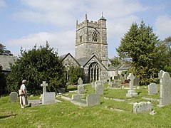
Blisland
Blisland
|
|
|---|---|
 Blisland Parish Church |
|
| Blisland shown within Cornwall | |
| Population | 608 (United Kingdom Census 2011 including Bradford and Lank) |
| OS grid reference | SX101732 |
| Civil parish |
|
| Unitary authority | |
| Ceremonial county | |
| Region | |
| Country | England |
| Sovereign state | United Kingdom |
| Post town | BODMIN |
| Postcode district | PL30 |
| Dialling code | 01208 |
| Police | Devon and Cornwall |
| Fire | Cornwall |
| Ambulance | South Western |
| EU Parliament | South West England |
| UK Parliament | |
Blisland (Cornish: Blyslann) is a village and civil parish in Cornwall, England, United Kingdom. It is approximately five miles northeast of Bodmin. According to the 2001 census, the parish had a population of 565. This had increased to 608 at the 2011 census.
The parish is entirely rural in character, the northeast being moorland and the southwest lower lying farmland. The parish is bordered to the north by St Breward parish; to the west by St Mabyn and Helland parishes; to the south by Cardinham, Warleggan, and St Neot parishes; and to the northeast by Altarnun parish.
The hamlets of Bradford, Keybridge, Merry Meeting, Pendrift, Tresarrett and Waterloo are in the parish. Blisland is sometimes said to be the only village in Cornwall with a village green, however Herodsfoot and Talskiddy are others.
The derivation of the placename is unclear – the earliest known form is Bleselonde in 1284. This appears to include the Old English land meaning estate, the first element is however obscure. Ekwall mentions forms such as Bloiston from documents 1177–1198 and suggests that the first element is the same as in Blisland (with -ton as suffix) and that it is the original Celtic name (etym. dub.).Charles Henderson in the Cornish Church Guide mentioned the older form as Bliston, thought to mean Heath-Town. In Domesday Book (1086) the manor is entered as Gluston and so probably it was really Bluston from Anglo-Saxon times to the 12th century, and by 1284 the new 'Blisland' form was adopted.
...
Wikipedia

