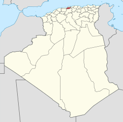
Blida Province
|
Blida Province ولاية البليدة |
|
|---|---|
| Province | |
 Map of Algeria highlighting Blida |
|
| Coordinates: 36°28′N 02°49′E / 36.467°N 2.817°ECoordinates: 36°28′N 02°49′E / 36.467°N 2.817°E | |
| Country |
|
| Capital | Blida |
| Government | |
| • PPA president | Mr. Kahla Mustapha (FLN) |
| • Wāli | Mr. Ouadah Hocine |
| Area | |
| • Total | 1,479 km2 (571 sq mi) |
| Elevation | 257 m (843 ft) |
| Population (2008) | |
| • Total | 1,009,892 |
| • Density | 680/km2 (1,800/sq mi) |
| Time zone | CET (UTC+01) |
| Area Code | +213 (0) 25 |
| ISO 3166 code | DZ-09 |
| Districts | 10 |
| Municipalities | 25 |
Blida (Arabic: ولاية البليدة) is a province (wilaya) in Algeria. Its capital is Blida. The Chréa National Park is situated here.
It is made up of 10 districts and 25 municipalities.
The districts are:
The municipalities are:
This province has one of the few habitat areas in Algeria that supports a sub-population of the Barbary macaque, Macaca sylvanus.
...
Wikipedia
