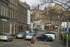
Blairgowrie, Perthshire
Blairgowrie
|
|
|---|---|
 Blairgowrie town centre |
|
| Blairgowrie shown within Perth and Kinross | |
| Population |
7,965 (2001 census) |
| OS grid reference | NO178452 |
| Council area | |
| Lieutenancy area | |
| Country | Scotland |
| Sovereign state | United Kingdom |
| Post town | BLAIRGOWRIE |
| Postcode district | PH10 |
| Dialling code | 01250 |
| Police | Scottish |
| Fire | Scottish |
| Ambulance | Scottish |
| EU Parliament | Scotland |
| UK Parliament | |
| Scottish Parliament | |
7,965 (2001 census)
Blairgowrie and Rattray (/blɛərˈɡaʊri ənd ˈrætreɪ/) is a twin burgh in Perth and Kinross, Scotland. Locals refer to the town as "Blair". Blairgowrie is the larger of the two former burghs which were united by an Act of Parliament in 1928 and lies on the southwest side of the River Ericht while Rattray is on the northeast side. Rattray claims to be the older and certainly Old Rattray, the area round Rattray Kirk, dates back to the 12th century. New Rattray, the area along the Boat Brae and Balmoral Road dates from 1777 when the River was spanned by the Brig o' Blair. The town lies on the north side of Strathmore at the foot of the Grampian Mountains. The west boundary is formed by the Knockie, a round grassy hill, and Craighall Gorge on the Ericht. Blairgowrie and Rattray developed over the centuries at the crossroads of several historic routes with links from the town to Perth, Coupar Angus, Alyth and Braemar. The roads to Coupar Angus and Braemar form part of General Wade's military road from Perth to Fort George. The town's centrepiece is the Wellmeadow, a grassy triangle in the middle of town which hosts regular markets and outdoor entertainment.
...
Wikipedia

