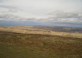
Black Mountain South Top
| Black Mountain South Top | |
|---|---|

|
|
| Highest point | |
| Elevation | 637 m (2,090 ft) |
| Prominence | 15 m (49 ft) |
| Parent peak | Black Mountain |
| Listing | Nuttall |
| Geography | |
| Location | Herefordshire, England / Powys, Wales |
| Parent range | Black Mountains |
| OS grid | SO255350 |
| Topo map | OS Landranger 161 |
| Climbing | |
| Easiest route | The Cat's back |
Black Mountain South Top is a top of Black Mountain in the Black Mountains (not to be confused with the Black Mountain range of hills). It is a top which falls exactly on the Welsh-English border, straddling Powys and Herefordshire. The Offa's Dyke Path passes over the summit.
The top is an undistinguished heathery bump on Hatterall Ridge. The summit is marked by a small pile of stones.
Coordinates: 52°00′30″N 3°05′05″W / 52.00833°N 3.08472°W
...
Wikipedia
