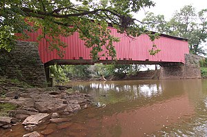
Bitzer's Mill Covered Bridge
| Bitzer's Mill Covered Bridge | |
| Eberly's Cider Mill, Martin's Mill, Big Conestoga #2, Fiand's, Fiantz's |
|
|
One of the sides of the bridge
|
|
| Official name: Big Conestoga #2 Bridge | |
| Country | United States |
|---|---|
| State | Pennsylvania |
| County | Lancaster |
| Township | West Earl |
| Road | SR 1013 (single lane) |
| Crosses | Conestoga River |
| Coordinates | 40°8′25.5″N 76°9′7″W / 40.140417°N 76.15194°WCoordinates: 40°8′25.5″N 76°9′7″W / 40.140417°N 76.15194°W |
| Length | 98 ft (30 m) |
| - Mainspan | 80 m (262 ft) |
| Width | 15 ft (5 m) |
| - Road width | 13 ft (4 m) |
| Overhead Clearance | 11.5 ft (4 m) |
| Builder | George Fink, Sam Reamsnyder |
| Design | Burr Arch Truss Bridge |
| Material | Wood |
| Built | 1846 |
| - Reconstructed | 1997 |
| Owned and Maintained by | Lancaster County |
| NBI Number | 361013025007460 |
| WGCB Number | 38-36-04 |
| NRHP Ref Number | 80003516 |
| Load | 20 short tons (18 t) |
| Added to NRHP | December 11, 1980 |
| MPS | Covered Bridges of Lancaster County TR |
The Bitzer's Mill Covered Bridge is a covered bridge that spans the Conestoga River in Lancaster County, Pennsylvania, United States. It is the oldest bridge in the county still in use. A county-owned and maintained bridge, its official designation is the Big Conestoga #2 Bridge. The bridge is also called Martin's Mill Bridge, Eberly's Cider Mill Covered Bridge, and Fiand's/Fiantz's Covered Bridge.
The bridge has a single span, wooden, double Burr arch trusses design with the addition of steel hanger rods. The deck is made from oak planks. Added later, secondary steel I-beams support the bridge from underneath. The bridge is painted red on the outside, the traditional color of Lancaster County covered bridges. The inside of the bridge is not painted. Both approaches to the bridge are painted in the traditional white color. As of July 2006, the bridge has some damage to its sides including some missing or broken panels.
The bridge's WGCB Number is 38-36-04. In 1980 it was added to the National Register of Historic Places as structure number 80003516. It is located at 40°8′25.8″N 76°9′7.2″W / 40.140500°N 76.152000°W (40.1405, -76.1520) near the junction of U.S. Route 222 and U.S. Route 322 southeast of Ephrata in West Earl Township. The bridge can be reached by going approximately 1.5 miles (2.4 km) south from U.S. Route 322 on Cabin Drive which becomes Conestoga Creek Road. A left onto Cider Mill Road leads straight to the bridge, which is visible from the intersection.
...
Wikipedia


