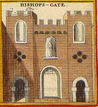
Bishopsgate
| Ward of Bishopsgate | |
|---|---|
 A circa 1650 print of the gate |
|
 Location within the City |
|
| Ward of Bishopsgate shown within Greater London | |
| Population | 222 (2011 Census Ward) |
| OS grid reference | TQ330813 |
| Sui generis | |
| Administrative area | Greater London |
| Region | |
| Country | England |
| Sovereign state | United Kingdom |
| Post town | LONDON |
| Postcode district | EC2 |
| Dialling code | 020 |
| Police | City of London |
| Fire | London |
| Ambulance | London |
| EU Parliament | London |
| UK Parliament | |
| London Assembly | |
Bishopsgate is one of the 25 wards of the City of London and also the name of a major road (part of the A10) between Gracechurch Street and Norton Folgate in the northeast corner of London's main financial district. Bishopsgate is named after one of the original eight gates in the London Wall. The site of this former gate is marked by a stone bishop's mitre, fixed high upon a building located at Bishopsgate's junction with Wormwood Street, by the gardens there and facing the Heron Tower.
Although tens of thousands of people commute to and work in the ward, it has a resident population of only 222 (2011).
The ward (which is large by City standards) is bounded by Worship Street to the north, where the edge of the City meets the boroughs of Islington and Hackney. It neighbours Portsoken ward and the borough of Tower Hamlets in the east. The western boundary is formed by Old Broad Street and Broad Street ward itself. Bishopsgate also bounds the wards of Aldgate (southeast), Coleman Street (west), Cornhill (southwest) and Lime Street (south). Bishopsgate ward straddles the (now former) line of the Wall and the old gate and is often (even today) divided into "Within" and "Without" parts, with a deputy (alderman) appointed for each part.
...
Wikipedia

