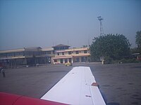
Biratnagar Airport
|
Biratnagar Airport Gograha Airport |
|||||||||||
|---|---|---|---|---|---|---|---|---|---|---|---|
 |
|||||||||||
| Summary | |||||||||||
| Airport type | Public | ||||||||||
| Owner | Nepal Government | ||||||||||
| Serves | Biratnagar, Nepal | ||||||||||
| Elevation AMSL | 236 ft / 72 m | ||||||||||
| Coordinates | 26°28′53″N 87°15′50″E / 26.48139°N 87.26389°ECoordinates: 26°28′53″N 87°15′50″E / 26.48139°N 87.26389°E | ||||||||||
| Map | |||||||||||
| Location of airport in Nepal | |||||||||||
| Runways | |||||||||||
|
|||||||||||
|
Source: DAFIF
|
|||||||||||
Biratnagar Airport (IATA: BIR, ICAO: VNVT) is an airport serving Biratnagar, a city of the Morang District in Province No. 1 in Nepal.
Owned and operated by the Government of Nepal, Biratnagar Airport commenced operations on 6 July 1958. The airport is located at an elevation of 236 feet (72 m) above mean sea level. It has one runway designated 09/27 with an asphalt surface measuring 1,505 by 30 metres (4,938 ft × 98 ft).
The airport is capable of handling aircraft from the Nepalese Army Air Service. The Nepalese government has approved making it the largest international airport in Nepal.
...
Wikipedia

