Billy Goat Trail
| Billy Goat Trail | |
|---|---|

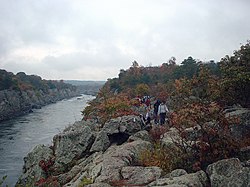
Scrambling over boulders on Section A. Mather Gorge at left.
|
|
| Length | 4.7 mi (7.6 km) |
| Location | Montgomery County, Maryland, United States |
| Trailheads |
C&O Canal Bear Island |
| Use | Hiking Trail Running |
| Hiking details | |
| Trail difficulty | Strenuous (Section A) Moderate (Section B) Easy (Section C) |
| Season | All year |
| Sights | Chesapeake and Ohio Canal National Historical Park |
Coordinates: 38°59′38″N 77°14′45″W / 38.9938°N 77.2458°W
The Billy Goat Trail is a 4.7-mile (7.6 km) hiking trail that follows a path between the C&O Canal and the Potomac River within the Chesapeake and Ohio Canal National Historical Park near Great Falls in Montgomery County, Maryland. The trail has three sections: Section A, the northernmost, is 1.7 miles (2.7 km); Section B is 1.4 miles (2.3 km); and Section C, the southernmost, is 1.6 miles (2.6 km)
Billy Goat Trail was laid out by the YMCA Triangle Club in 1919.
Section A of the trail, by far the most popular, is on Bear Island and traverses rough and rocky terrain, including a steep climb along a cliff face along the Potomac River's Mather Gorge. At another point in the trail, hikers are required to scramble over and around huge boulders. Sections B and C are less strenuous; section B requires only one brief scramble, and section C has none. Most of the trail is well marked with light blue trail blazes.
Section A is best accessed from the Great Falls Tavern Visitor Center.
...
Wikipedia
