Biggleswade
| Biggleswade | |
|---|---|
 Town council logo and de facto town arms |
|
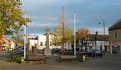
 Biggleswade town centre |
|
| Biggleswade shown within Bedfordshire | |
| Population | 16,551 (2011 Census) |
| OS grid reference | TL1944 |
| Civil parish |
|
| Unitary authority | |
| Ceremonial county | |
| Region | |
| Country | England |
| Sovereign state | United Kingdom |
| Post town | BIGGLESWADE |
| Postcode district | SG18 |
| Dialling code | 01767 |
| Police | Bedfordshire |
| Fire | Bedfordshire and Luton |
| Ambulance | East of England |
| EU Parliament | East of England |
| UK Parliament | |
Biggleswade is a market town and civil parish located on the River Ivel in Bedfordshire, England. It has grown in population by nearly 10% over the past decade, primarily due to good transport links, being situated along the A1 road between London and the North, as well as having a railway station on the main rail link North from London (the East Coast Main Line). New housing developments mean that expansion is predicted to continue into the foreseeable future.
Biggleswade is located about 40 miles (60 km) north of Central London and 20 miles (30 km) to the west-south-west of Cambridge. Situated with a station on the East Coast Main Line, Biggleswade is around half-an-hour from the capital city by train. In 2011 the population of the town was about 16,550. The Biggleswade civil parish also includes the nearby hamlet of Holme, Bedfordshire.
The town lies just off the A1, Britain's "Great North Road" between London and Edinburgh - and the B1040, which leads to Potton in the north, runs through the town. Biggleswade is also situated on the A6001, which leads to Langford and Henlow to the south.
At the north end of Biggleswade past Shortmead House lies a solar power farm, whilst a wind farm of ten turbines sits beyond the south end of the town, towards Langford.
The area around Biggleswade is thought to have been inhabited from around 10,000 BC, with arrowheads dating from this period believed to have been found in the region. In Roman times, a loop road known as the White Way passed through Biggleswade (possibly along the course of the present-day Drove Road), linking up with the Ermine Way at Godmanchester.
...
Wikipedia

