Biddestone
| Biddestone | |
|---|---|
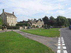
 Biddestone surrounds a large village green |
|
| Biddestone shown within Wiltshire | |
| Population | 498 (in 2011) |
| OS grid reference | ST863735 |
| Unitary authority | |
| Ceremonial county | |
| Region | |
| Country | England |
| Sovereign state | United Kingdom |
| Post town | CHIPPENHAM |
| Postcode district | SN14 7 |
| Dialling code | 01249 |
| Police | Wiltshire |
| Fire | Dorset and Wiltshire |
| Ambulance | South Western |
| EU Parliament | South West England |
| UK Parliament | |
| Website | Village |
Biddestone is a village and civil parish in northwest Wiltshire, England, about 3 miles (5 km) west of Chippenham and 2 miles (3.2 km) north of Corsham. The parish includes the smaller settlement of Slaughterford.
The Bybrook River forms the western boundary of the parish, while the northern boundary follows approximately the Bristol to Chippenham road, now the A420.
The parish is just inside the eastern boundary of the Cotswolds Area of Outstanding Natural Beauty. Sites of Special Scientific Interest include Honeybrook Farm and Colerne Park and Monk's Wood, both near Slaughterford.
The Manor House (Grade II* listed) and Manor Farmhouse are from the 17th century, as are Pool Farmhouse and Elm Cottage.
The civil parish elects a parish council. It is in the area of Wiltshire Council unitary authority, which is responsible for all significant local government functions.
The Church of England parish church of St Nicholas is Grade I listed. It has a Norman doorway and windows, and a 13th-century bell turret on its roof.
A church of St Peter, on the eastern side of the village, was demolished in 1846. Possibly of Saxon origin, it had been rebuilt in 1430.
Biddestone Baptist chapel, dated 1832 and formerly known as Ebenezer Chapel, is Grade II listed. By 2009 it had fallen into disuse.
...
Wikipedia

