Bessemer Airport
| Bessemer Airport | |||||||||||
|---|---|---|---|---|---|---|---|---|---|---|---|

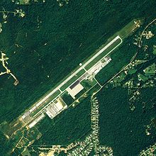
NAIP aerial image, 2006
|
|||||||||||
| Summary | |||||||||||
| Airport type | Public | ||||||||||
| Owner | City of Bessemer | ||||||||||
| Serves | Bessemer, Alabama | ||||||||||
| Elevation AMSL | 700 ft / 213 m | ||||||||||
| Coordinates | 33°18′45″N 086°55′35″W / 33.31250°N 86.92639°W | ||||||||||
| Website | http://bessemermunicipalairport.com | ||||||||||
| Runways | |||||||||||
|
|||||||||||
| Statistics (2017) | |||||||||||
|
|||||||||||
|
Source: Federal Aviation Administration
|
|||||||||||
| Aircraft Operations (2016) | 102,600 |
|---|---|
| Based Aircraft | 117 |
Bessemer Airport (ICAO: KEKY, FAA LID: EKY, formerly 2A3) is a city-owned public-use airport located three nautical miles (6 km) southeast of the central business district of Bessemer, a city in Jefferson County, Alabama, United States. According to the FAA's National Plan of Integrated Airport Systems for 2009–2013, it is categorized as a reliever airport for the Birmingham-Shuttlesworth International Airport.
Although many U.S. airports use the same three-letter location identifier for the FAA and IATA, this facility is assigned EKY by the FAA but has no designation from the IATA.
Bessemer Airport covers an area of 380 acres (150 ha) at an elevation of 700 feet (213 m) above mean sea level. It has one runway designated 5/23 with an asphalt surface measuring 6,007 by 100 feet (1,831 x 30 m). An Instrument Landing System was installed in 2000. The airport received funding to expand the runway from 5,700 feet (1,737 m). A Civil Air Patrol squadron also operates from this airport.
...
Wikipedia
