Berlin wall
| Berlin Wall | |
|---|---|

View from the West Berlin side of graffiti art on the Wall in 1986. The Wall's "death strip", on the east side of the Wall, here follows the curve of the Luisenstadt Canal (filled in 1932).
|
|

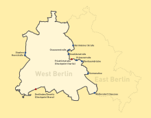
Map of the location of the Berlin Wall, showing checkpoints
|
|
| General information | |
| Type | Wall |
| Country | |
| Coordinates | 52°30′58″N 13°22′37″E / 52.516111°N 13.376944°ECoordinates: 52°30′58″N 13°22′37″E / 52.516111°N 13.376944°E |
| Construction started | 13 August 1961 |
| Dimensions | |
| Other dimensions |
|
| Technical details | |
| Size | 155 km (96.3 mi) |
The Berlin Wall (German: Berliner Mauer) was a barrier that divided Berlin from 1961 to 1989. Constructed by the German Democratic Republic (GDR, East Germany), starting on 13 August 1961, the Wall completely cut off (by land) West Berlin from surrounding East Germany and from East Berlin until government officials opened it in November 1989. Its demolition officially began on 13 June 1990 and was completed in 1992. The barrier included guard towers placed along large concrete walls, which circumscribed a wide area (later known as the "death strip") that contained anti-vehicle trenches, "fakir beds" and other defenses. The Eastern Bloc claimed that the Wall was erected to protect its population from fascist elements conspiring to prevent the "will of the people" in building a socialist state in East Germany. In practice, the Wall served to prevent the massive emigration and defection that had marked East Germany and the communist Eastern Bloc during the post-World War II period.
The Berlin Wall was officially referred to as the "Anti-Fascist Protective Wall" (German: Antifaschistischer Schutzwall) by GDR authorities, implying that the NATO countries and West Germany in particular were considered equal to "fascists" by GDR propaganda. The West Berlin city government sometimes referred to it as the "Wall of Shame"—a term coined by mayor Willy Brandt—while condemning the Wall's restriction on freedom of movement. Along with the separate and much longer Inner German border (IGB), which demarcated the border between East and West Germany, it came to symbolize a physical marker of the "Iron Curtain" that separated Western Europe and the Eastern Bloc during the Cold War.
...
Wikipedia
