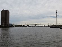
Berkley Bridge (Virginia)
| I-264 Berkley Bridge | |
|---|---|

Berkley Bridge in 2016
|
|
| Coordinates | 36°50′18″N 76°17′12″W / 36.83833°N 76.28667°WCoordinates: 36°50′18″N 76°17′12″W / 36.83833°N 76.28667°W |
| Carries | eight lanes of |
| Crosses | Eastern Branch of the Elizabeth River |
| Locale | Norfolk, Virginia |
| Official name | Berkley Bridge |
| Owner | Virginia Department of Transportation |
| Maintained by | Virginia Department of Transportation |
| ID number |
|
| Characteristics | |
| Design | twin-leaf bascule bridge |
| Material | steel |
| Total length | 2,124.1 feet (0.40229 mi) |
| Width | 54.1 feet (16.5 m) |
| Water depth | 45 feet (14 m) |
| Traversable? | yes as restricted by C.F.R. 117.1007 |
| Longest span | 2 x 230.0 feet (70.1 m) |
| No. of spans | 2 |
| Clearance below | 48 feet (15 m) |
| History | |
| Opened | 1952 |
| Rebuilt | 1991 |
 |
|
| References | |
|
|
"Berkley Bridge". Bridgehunter.com.
The Interstate 264 Berkley Bridge is a double-leaf bascule bridge that crosses the Eastern Branch of the Elizabeth River in Norfolk, Virginia, United States. It carries Interstate 264 (I-264), U.S. Route 460 Alternate (US 460 Alt.), and State Route 337 (SR 337) across the river, connecting the Berkley neighborhood south of the river with downtown Norfolk to the north. The toll-free facility is one of only a small number of movable bridges on the Interstate Highway System, and is the first of two in the Hampton Roads region, predating the High Rise Bridge. It is named for the former Town of Berkley that is now a part of the City of Norfolk.
There have been several incarnations of a Berkley Bridge. An earlier Berkley Bridge was built before 1922, east of the present one, along Main Street. A replacement for that span, in the present location, was completed in 1952 as part of the original Norfolk–Portsmouth Bridge-Tunnel project between the city of Portsmouth and Norfolk. The project was funded with toll revenue bonds. When the bonds were fully repaid, the tolls were removed.
...
Wikipedia
