Benton, Columbia County, Pennsylvania
| Benton, Pennsylvania | ||
|---|---|---|
| Borough | ||

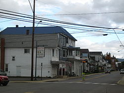
View north on PA 487 in Benton in October 2012
|
||
|
||
 Map showing Benton in Columbia County |
||
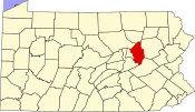
 Map showing Columbia County in Pennsylvania |
||
| Location of Benton in Pennsylvania | ||
| Coordinates: 41°11′46″N 76°23′00″W / 41.19611°N 76.38333°WCoordinates: 41°11′46″N 76°23′00″W / 41.19611°N 76.38333°W | ||
| Country | United States | |
| State | Pennsylvania | |
| County | Columbia | |
| Settled | 1833 | |
| Incorporated | 1894 | |
| Government | ||
| • Type | Borough Council | |
| Area | ||
| • Total | 0.61 sq mi (1.59 km2) | |
| • Land | 0.60 sq mi (1.55 km2) | |
| • Water | 0.02 sq mi (0.05 km2) | |
| Elevation | 765 ft (233 m) | |
| Population (2010) | ||
| • Total | 824 | |
| • Density | 1,380/sq mi (533.0/km2) | |
| Time zone | Eastern (EST) (UTC-5) | |
| • Summer (DST) | EDT (UTC-4) | |
| ZIP code | 17814 | |
| Area code(s) | 570 | |
| Website | www |
|
Benton is a borough in Columbia County, Pennsylvania, United States. The population was 824 at the 2010 census. It is part of the Bloomsburg–Berwick Micropolitan Statistical Area.
Benton is located in northern Columbia County at 41°11′46″N 76°23′0″W / 41.19611°N 76.38333°W (41.196144, -76.383354). It is surrounded by Benton Township, a separate municipality. According to the United States Census Bureau, the borough has a total area of 0.61 square miles (1.59 km2), of which 0.60 square miles (1.55 km2) is land and 0.02 square miles (0.05 km2), or 2.96%, is water.Fishing Creek, a south-flowing tributary of the Susquehanna River, runs through the eastern part of Benton.
Benton is served by the following major roads:
The two highways run together as Main Street through the center of town.
The Benton area was first settled by two families in 1792. A schoolhouse was opened in 1799. Starting around 1860, tanning and lumber industries began to grow north of the borough. By 1868, Benton had about fifty houses. The Benton dam was built in 1915.
As of the census of 2000, there were 955 people, 394 households, and 265 families residing in the borough. The population density was 1,503.6 people per square mile (576.1/km²). There were 436 housing units at an average density of 686.5 per square mile (263.0/km²). The racial makeup of the borough was 99.69% White, 0.10% African American, and 0.21% from two or more races. Hispanic or Latino of any race were 0.10% of the population.
...
Wikipedia


