Bengeo
Bengeo /ˈbɛn.dʒoʊ/ is a suburb and former village on the northwest edge of the county town of Hertford in Hertfordshire, England. It is an electoral ward of Hertford.
Bengeo is on a rise between the River Beane and River Rib overlooking Hartham Common. Its toponym is derived from an Old English name meaning spur or ridge over the River Beane. The Domesday Book of 1086 records it as Belingehou. It evolved through forms including Beneggho and Beningho in the 13th century, Bengeho in the 15th century and Benjow in the 16th century before reaching its current form.
See map of Bengeo.
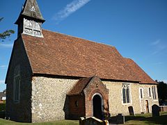
Other than the south east corner which adjoins Hertford, Bengeo is mostly surrounded by countryside. Informally (the terms having no official status) Bengeo consists of Upper and Lower Bengeo; Upper Bengeo is the area at the top of Port Hill leading out of Hertford town centre, while Lower Bengeo is the area on the side of the hill and centred on Byde Street. On an approximate north-south trajectory Bengeo is bisected by the B158, known as Port Hill as it leaves Hertford and climbs the hill to Upper Bengeo and then as Bengeo Street as it continues through, and then out of, Bengeo to the north. Leaving Port Hill to the east runs The Warren, an ancient footpath along the edge of the River Beane and Hartham Common leading to the ancient church of St Leonard.
...
Wikipedia


