Beltana
|
Beltana South Australia |
|
|---|---|

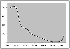
Beltana population since 1880
|
|
| Coordinates | 30°49′S 138°24′E / 30.817°S 138.400°ECoordinates: 30°49′S 138°24′E / 30.817°S 138.400°E |
| Population | 83 (2006 census) |
| Established | 1873 |
| Postcode(s) | 5730 |
| Elevation | 296 m (971 ft) |
| Location |
|
| LGA(s) | Outback Communities Authority |
| State electorate(s) | Stuart |
| Federal Division(s) | Grey |
Beltana is a semi-ghost town 540 kilometres (336 mi) north of Adelaide, South Australia. Beltana is known for continuing to exist long after the reasons for its existence had ceased. The town's history began in the 1870s with the advent of copper mining in the area, construction of the Australian Overland Telegraph Line and The Ghan railroad and began to decline in 1941 with the beginning of coal mining at Leigh Creek. The fortune of the town was sealed by the 1983 realignment of the main road away from the town. The town, adjacent cemetery and railway structures are now part of a designated State Heritage Area declared in 1987.
Beltana has important links with the overland telegraph, transcontinental railway, mining, outback services, Australian Inland Mission and also has Afghan sites relating to its past as a camel-based transport centre.
The town has had horse racing since 1876, and the annual picnic races and gymkhana and biennial pastoral field day are still continued. There are services and accommodation available at Beltana station and there is an interpretive history trail and self-guided tour around the town. The Beltana roadhouse, now 12 km from Beltana on the main highway between Parachilna and Leigh Creek, acted as the town's local store until it closed in 2016.
...
Wikipedia

