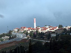
Beit Horon
| Beit Horon | |
|---|---|
 |
|
| Coordinates: 31°52′36.12″N 35°7′43.32″E / 31.8767000°N 35.1287000°ECoordinates: 31°52′36.12″N 35°7′43.32″E / 31.8767000°N 35.1287000°E | |
| District | Judea and Samaria Area |
| Council | Mateh Binyamin |
| Region | West Bank |
| Affiliation | Amana |
| Founded | 1977 |
| Population (2015) | 1,228 |
Beit Horon (Hebrew: בֵּית חוֹרוֹן) is a communal Israeli settlement in the West Bank. Bordering Route 443 between Modi'in and Jerusalem, the biblical pass of Beit Horon (Joshua 10:10), after which it is named, it falls under the jurisdiction of Mateh Binyamin Regional Council. In 2015 it had a population of 1,228.
The international community considers Israeli settlements in the West Bank illegal under international law, but the Israeli government disputes this.
Beit Horon was established on 1 December 1977. It is a joint Secular and Orthodox community.
A religious elementary school located in Beit Horon serves local children as well as those from surrounding villages. There are also three nurseries and kindergarten, two synagogues, a kollel, a mikvah for women and men, and a library.
...
Wikipedia

