Beer, Devon
| Beer | |
|---|---|
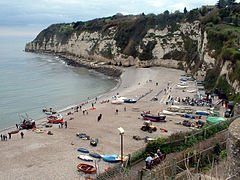
 Beach at Beer, with Beer Head behind. |
|
| Beer shown within Devon | |
| Area | 6.7 km2 (2.6 sq mi) |
| Population | 1,317 (2011) |
| • Density | 197/km2 (510/sq mi) |
| OS grid reference | SY2289 |
| Civil parish |
|
| District | |
| Shire county | |
| Region | |
| Country | England |
| Sovereign state | United Kingdom |
| Post town | SEATON |
| Postcode district | EX12 |
| Dialling code | 01297 |
| Police | Devon and Cornwall |
| Fire | Devon and Somerset |
| Ambulance | South Western |
| EU Parliament | South West England |
| UK Parliament | |
Beer is a village and civil parish in the East Devon district of Devon, England. The village faces Lyme Bay and is a little over one mile west of the town of Seaton. At the 2011 Census, the parish had a population of 1,317.
The village is situated on the 95-mile long Jurassic Coast, England's first natural World Heritage Site. Its picturesque cliffs, including Beer Head, form part of the South West Coast Path.
Beer is mentioned in the Domesday Book of 1086, at which time it was located within Colyton hundred and had 28 households. Its name is not derived from the drink, but from the Old English word bearu, meaning "grove" and referring to the original forestation that surrounded the village.
It is a pretty coastal village that grew up around a smugglers' cove and caves which were once used to store contraband goods. These are now part of the attraction of the village. Many of the buildings are faced with flint, a hard glassy stone found in the local chalk rock.
Historically, the main sources of income for the village include fishing and lace production. Boats are winched up the beach as there is no harbour, and fresh fish is sold nearby. Nowadays small electrically driven winches using steel cables or tractors are located on the beach to haul boats in. Higher up is an old manual capstan operated by up to 20 men, now disused.
A brook winds its way in an open conduit alongside the main road down to the sea.
A WW2 pillbox is located close to the western side of the beach exit.
...
Wikipedia

