Bedfordshire, England
| Bedfordshire | |||
|---|---|---|---|
| County | |||
|
|||
 Bedfordshire in England |
|||
| Coordinates: 52°05′N 0°25′W / 52.083°N 0.417°WCoordinates: 52°05′N 0°25′W / 52.083°N 0.417°W | |||
| Sovereign state |
|
||
| Country |
|
||
| Region | East | ||
| Established | Ancient | ||
| Ceremonial county | |||
| Lord Lieutenant | Helen Nellis | ||
| High Sheriff | Vinod Tailor | ||
| Area | 1,235 km2 (477 sq mi) | ||
| • Ranked | 41st of 48 | ||
| Population (mid-2016 est.) | 664,500 | ||
| • Ranked | 36th of 48 | ||
| Density | 537/km2 (1,390/sq mi) | ||
| Ethnicity | 86.3% White 8.3% S.Asian 2.9% Black |
||
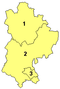
 Districts of Bedfordshire Unitary |
|||
| Districts | |||
| Members of Parliament | List of MPs | ||
| Police | Bedfordshire Police | ||
| Time zone | Greenwich Mean Time (UTC) | ||
| • Summer (DST) | British Summer Time (UTC+1) | ||
Bedfordshire (/ˈbɛdfərdʃər/ or /-ʃɪər/; abbreviated Beds.) is a county in the East of England. It is a ceremonial county and an historic county, covered by three unitary authorities: Bedford, Central Bedfordshire, and Luton.
Bedfordshire is bordered by Cambridgeshire to the east/northeast, Northamptonshire to the north, Buckinghamshire to the west and Hertfordshire to the east/southeast. It is the fourteenth most densely populated county of England, with over half the population of the county living in the two largest built-up areas: Luton (236,000) and the county town, Bedford (102,000). The highest elevation point is 243 metres (797 ft) on Dunstable Downs in the Chilterns.
...
Wikipedia

