Beckwourth Pass
| Beckwourth Pass | |
|---|---|

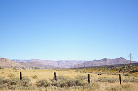
Beckwourth Pass as seen from the Feather River Route in the Sierra Valley looking east
|
|
| Elevation | 5,221 ft (1,591 m) |
| Traversed by |
Feather River Route |
| Location | Plumas County |
| Range | Sierra Nevada (U.S.) |
| Coordinates | 39°47′30″N 120°6′28″W / 39.79167°N 120.10778°W |
| Reference no. | 336 |
Beckwourth Pass is the lowest mountain pass in the Sierra Nevada mountain range at an elevation of 5,221 feet (1,591 m).
Beckwourth Pass is located at the eastern edge of Sierra Valley at Chilcoot-Vinton, California in Plumas County, 20 miles (32 km) east of Portola, California and 25 miles (40 km) northwest of Reno, Nevada.
California State Route 70 crosses over Beckwourth Pass and the Feather River Route of the Union Pacific Railroad crosses beneath it via the Chilcoot Tunnel. Route 70 and the railroad line provide an alternate route between Sacramento, California and Reno, Nevada when Interstate 80 and the Overland Route, which cross the Sierra Nevada near Donner Pass, are impassable due to winter storms.
In 1850 James Beckwourth discovered Beckwourth Pass and developed his Beckwourth Trail from Truckee Meadows (what is now known as Sparks, Nevada) through the pass into California and on to Marysville.
In late summer of 1851, James Beckwourth led the first wagon train of settlers along the Beckwourth Trail into Marysville. Between 1851 and 1854, 1,200 emigrants used the trail.
The Beckwourth Trail was used during the California Gold Rush until about 1855, when the railroad supplanted the wagon train as the preferred method of travelling to California.
...
Wikipedia
