Bear River (Feather River)
| Bear River | |
| River | |
|
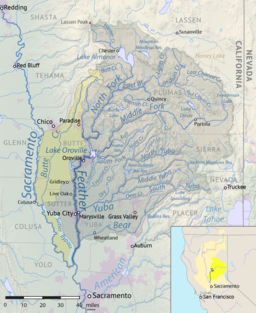
Map of the Bear River watershed
|
|
| Country | United States |
|---|---|
| State | California |
| Source | |
| - location | Sierra Nevada |
| - elevation | 4,800 ft (1,463 m) |
| - coordinates | 39°18′29″N 120°39′23″W / 39.30806°N 120.65639°W |
| Mouth | Feather River |
| - location | Sacramento Valley, United States |
| - elevation | 23 ft (7 m) |
| - coordinates | 38°56′23″N 121°34′51″W / 38.93972°N 121.58083°WCoordinates: 38°56′23″N 121°34′51″W / 38.93972°N 121.58083°W |
| Length | 73 mi (117 km) |
| Basin | 295 sq mi (764 km2) |
| Discharge | for Wheatland, CA |
| - average | 410 cu ft/s (12 m3/s) |
| - max | 48,000 cu ft/s (1,359 m3/s) |
| - min | 0 cu ft/s (0 m3/s) |
|
Map of the Feather River watershed including the Bear River
|
|
The Bear River is a tributary of the Feather River in the Sierra Nevada, winding through four California counties: Yuba, Sutter, Placer, and Nevada. About 73 miles (117 km) long, the river flows generally southwest through the Sierra then west through the Central Valley, draining a narrow, rugged watershed of 295 square miles (760 km2).
The Bear River originates at Emigrant Gap, as a tiny stream on the border of Nevada and Placer Counties in the Tahoe National Forest. The headwaters are on a ridge immediately to the south of the South Yuba River and north of the North Fork American River. The river flows west into the Bear Valley then enters a deep and narrow gorge, passing the community of Dutch Flat. Continuing along the Nevada–Placer County line it receives Steephollow Creek from the north before widening into Rollins Reservoir, formed by the 242-foot (74 m) high Rollins Dam east of Chicago Park. While part of the reservoir, the river is joined by Greenhorn Creek from the north.
Below the dam the river flows southwest through the Sierra foothills, past Colfax and Meadow Vista, through Lake Combie and a short but rugged gorge above Garden Bar. Shortly downstream it widens into Camp Far West Reservoir, where it begins to define the Placer–Yuba County border. Further west it flows into the Sacramento Valley where it forms a large alluvial floodplain. Starting at Wheatland it forms the border of Yuba and Sutter Counties. A few miles below this point it receives Dry Creek from the north, then flows into the Feather River at Nicolaus, 11 miles (18 km) above the Feather's confluence with the larger Sacramento River, and about 20 miles (32 km) due south of Yuba City–Marysville.
...
Wikipedia


