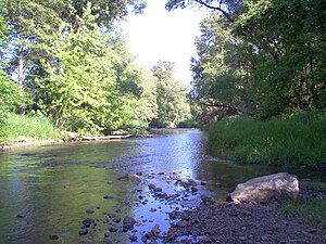
Bear Creek (Rogue River)
| Bear Creek | |
| Country | United States |
|---|---|
| State | Oregon |
| County | Jackson |
| Source | |
| - location | Near Emigrant Lake |
| - elevation | 1,842 ft (561 m) |
| - coordinates | 42°11′40″N 122°39′52″W / 42.19444°N 122.66444°W |
| Mouth | Rogue River |
| - location | Central Point |
| - elevation | 1,168 ft (356 m) |
| - coordinates | 42°25′56″N 122°58′13″W / 42.43222°N 122.97028°WCoordinates: 42°25′56″N 122°58′13″W / 42.43222°N 122.97028°W |
| Length | 28.80 mi (46.35 km) |
| Basin | 361 sq mi (935 km2) |
| Discharge | for Medford, Oregon |
| - average | 114 cu ft/s (3.23 m3/s) |
| - max | 10,900 cu ft/s (308.65 m3/s) |
| - min | 0.2 cu ft/s (0.01 m3/s) |
|
Route of Bear Creek
|
|
Bear Creek is the name of a stream located entirely within Jackson County, Oregon. The stream drains approximately 400 square miles (1,000 km2) of the Rogue Valley and discharges an annual average of 114 cubic feet per second (3.2 m3/s) into the Rogue River. It begins near Emigrant Lake and travels 28.8 miles (46.3 km) through the municipalities of Ashland, Talent, Phoenix, Medford, and Central Point.
Prior to the arrival of settlers in the 1850s, the Bear Creek Valley was home to three Native American tribes; these were the Takelmas, the Latgawas, and the Shastas. The scattered camps hunted deer and elk, fished for salmon, and consumed plums, sunflowers, and root crops. When the area was originally settled, the stream was called Si-ku-ptat by the natives and may have been known as Stewart River by settlers.
Various forced migrations occurred during the 1850s in which almost all of the Native American inhabitants were displaced to Indian Reservations by 1857.Farmers and ranchers continued to acquire land claims, and when the Oregon and California Railroad arrived in 1883, Bear Creek was chosen as the route to follow.
...
Wikipedia


