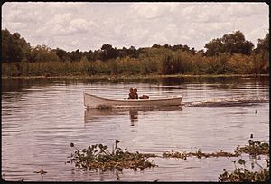
Bayou Gauche, Louisiana
| Bayou Gauche | |
| Census-designated place | |
|
Fishing in the Bayou Gauche wetlands.
|
|
| Country | United States |
|---|---|
| State | Louisiana |
| Parish | St. Charles |
| Elevation | 3 ft (0.9 m) |
| Coordinates | 29°49′31″N 90°26′05″W / 29.82528°N 90.43472°WCoordinates: 29°49′31″N 90°26′05″W / 29.82528°N 90.43472°W |
| Area | 20.2 sq mi (52.3 km2) |
| - land | 17.6 sq mi (46 km2) |
| - water | 2.6 sq mi (7 km2), 12.87% |
| Population | 1,770 (2000) |
| Density | 100.7/sq mi (38.9/km2) |
| Timezone | CST (UTC-6) |
| - summer (DST) | CDT (UTC-5) |
| Area code | 985 |
Bayou Gauche is a census-designated place—CDP and fishing village, with an adjacent natural bayou and wetlands. It is located within St. Charles Parish, in southeastern Louisiana, of the Southern United States.
Bayou Gauche is part of the Greater New Orleans region. It is located at 29°49′31″N 90°26′5″W / 29.82528°N 90.43472°W (29.825162, -90.434727).
According to the United States Census Bureau, the designated CDP has a total area of 20.2 square miles (52 km2), of which, 17.6 square miles (46 km2) is land, and 2.6 square miles (6.7 km2) (12.93%) is water.
The fishing and shellfish industries have been important in the local economy. Some residences for people in those fields, and their families, are stilt houses in the bayou and wetlands.
Oil wells for petroleum production are also present.
As of the census of 2000, there were 1,770 people, 598 households, and 508 families residing in the CDP. The population density was 100.7 people per square mile (38.9/km²). There were 637 housing units at an average density of 36.2 per square mile (14.0/km²).
The racial makeup of the CDP was 96.84% White, 1.53% African American, 0.28% Native American, 0.11% Asian, 0.85% from other races, and 0.40% from two or more races. Hispanic or Latino of any race were 1.47% of the population.
...
Wikipedia


