Battambang province
|
Battambang បាត់ដំបង |
|
|---|---|
| Province | |

Battambang Statue
|
|
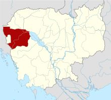
 Map of Cambodia highlighting Battambang Province |
|
| Country |
|
| Provincial status | 1907 |
| Capital | Battambang |
| Government | |
| • Governor | Chan Sophal (CPP) |
| Area | |
| • Total | 11,702.0 km2 (4,518.2 sq mi) |
| Area rank | Ranked 5th |
| Population (2008) | |
| • Total | 1,036,523 |
| • Rank | Ranked 3rd |
| • Density | 89/km2 (230/sq mi) |
| • Density rank | Ranked 13th |
| Time zone | Cambodia Standard Time (UTC+7) |
| ISO 3166 code | KH-2 |
Battambang (Khmer: បាត់ដំបង, IPA: [ˌɓat ɗɑm ˈɓɑːŋ], "Loss of Staff") is a province (khaet) of Cambodia located in the far northwest. Bordering provinces are Banteay Meanchey to the north, Pursat to the east and south, Siem Reap to the northeast, and Pailin to the west. The northern and southern extremes of the province's western boundaries form part of the international border with Thailand. In addition, Tonle Sap forms part of the northeastern boundary between Siem Reap and Pursat. Its capital and largest city is Battambang.
With a population of 1,036,523, it ranks as the third most populous province. In land area, Battambang is the fifth largest province of Cambodia. Battambang is one of the provinces included in the Tonle Sap Biosphere Reserve. The province's fertile rice fields have led to a mostly agricultural economy giving rise to the moniker "the Rice Bowl of Cambodia". The province features a range of cultures as well as natural resources. Seventy five percent of the area is jungles and mountains. The area has a tropical climate.
Battambang literally means "Loss of Staff" in Khmer, referring to the local legend of Preah Bat Dambang Kranhoung. Stone inscriptions discovered from pre-Angkorian and Angkorian eras have as yet not mentioned any contemporary villages or districts called "Battambang" but according to the document Mohachun Khmer, "Srok Battambang" (Battambang district) was used during the Angkor and post-Angkor eras.
Battambang is subdivided into 14 districts (Khmer: ស្រុក, srok) which are further subdivided into 96 subdistricts (Khmer: ឃុំ, khum) and 799 villages (Khmer: ភូមិ, phum).
...
Wikipedia
