Bassenthwaite Lake
| Bassenthwaite Lake | |
|---|---|

View from Blackstock Point
|
|

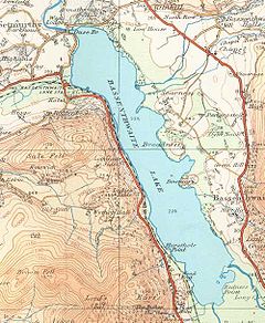
Map (1925)
|
|
| Location | Lake District |
| Coordinates | 54°39′N 3°13′W / 54.650°N 3.217°WCoordinates: 54°39′N 3°13′W / 54.650°N 3.217°W |
| Primary inflows |
River Derwent Newlands Beck |
| Primary outflows | River Derwent |
| Catchment area | 96.5 sq mi (250 km2) |
| Basin countries | United Kingdom |
| Max. length | 4 mi (6.4 km) |
| Max. width | 0.8 mi (1.3 km) |
| Surface area | 1.98 sq mi (5.1 km2) |
| Max. depth | 70 ft (21 m) |
| Shore length1 | 11.3 mi (18.2 km) |
| Surface elevation | 223 ft (68 m) |
| Islands | 0 |
| 1 Shore length is not a well-defined measure. | |
Bassenthwaite Lake is one of the largest water bodies in the English Lake District. It is long and narrow, approximately 4 miles (6.4 km) long and 3⁄4-mile (1.2 km) wide, but is also extremely shallow, with a maximum depth of about 70 ft (21 m).
It is the only body of water in the Lake District to use the word "lake" in its name, all the others being "waters" (for example, Derwentwater), "meres" (for example, Windermere) or "tarns" (for example, Dock Tarn). It is fed by, and drains into, the River Derwent. The lake lies at the foot of Skiddaw, near the town of Keswick. Some maps dating from the 18th century do in fact mark this lake with the name Bassenwater, and the use of the name Broadwater for this lake is also attested.
The A66 dual carriageway runs roughly north/south along the western side of the lake. The lay-bys are popular spots for photographers and bird watchers looking for osprey. The section running south towards Keswick was built along the course of the former Cockermouth, Keswick and Penrith railway line.
Like the other Lake District lakes, Bassenthwaite Lake lies in a glacially eroded valley, left after the last glaciation. Bassenthwaite Lake is linked to Derwent Water by the River Derwent, which crosses the 3-mile (4.8 km) alluvial plain between the two lakes. There has been speculation that Derwent Water and Bassenthwaite Lake were once one larger lake with the alluvial flats now separating them formed from partial infill of the original basin.
'Bassenthwaite' is "'Bastun's clearing', pers.[onal] n.[ame] plus 'þveit' 'clearing', also 'common', 'lake'. The 1st el[ement] is usually taken to be the Anglo-French nickname or surname 'Bastun', originally meaning 'stick', while the 2nd is ON 'þveit' 'clearing'. The lake, in early times known as 'Bastun's water', takes its name from the village." (ON=Old Norse).
...
Wikipedia
