Banteay Chhmar
|
Banteay Chhmar បន្ទាយឆ្មារ |
|
|---|---|
| Commune and village | |
 |
|
| Location within Cambodia | |
| Coordinates: 14°4′16″N 103°5′59″E / 14.07111°N 103.09972°ECoordinates: 14°4′16″N 103°5′59″E / 14.07111°N 103.09972°E | |
| Country |
|
| Province | Banteay Meanchey |
| District | Thma Puok District |
| Villages | 14 |
| Time zone | UTC+07 |
Banteay Chhmar (Khmer: បន្ទាយឆ្មារ) is a commune (khum) in Thma Puok District in Banteay Meanchey province in northwest Cambodia. It is located 63 km north of Sisophon and about 20 km east of the Thai border. The commune of Banteay Chhmar contains 14 villages.
The massive temple of Banteay Chhmar, along with its satellite shrines and reservoir (baray), comprises one of the most important and least understood archaeological complexes from Cambodia's Angkor period.
Like Angkor Thom, the temple of Banteay Chhmar was accomplished during the reign of Jayavarman VII in the late 12th or early 13th century. One of the temple's shrines once held an image of Srindrakumararajaputra (the crown prince), a son of Jayavarman VII who died before him. The temple doors record Yasovarman I's failed invasion of Champa.
The long Old Khmer inscription found at the site (K.227), and now on display in the National Museum, Phnom Penh, relates how Prince Srindrakumara was protected on two different occasions by four companions in arms, once against Rahu, and once on a military campaign against Champa. Their four statues, with one of the prince, was placed in the central chapel.
Another bas-relief states Yasovarman II was attacked by Rahu, but "saved by a young prince."
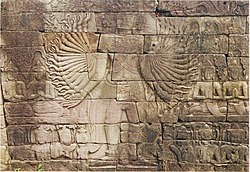
The complex resembles Angkor Thom and other structures attributed to Jayavarman VII. It is one of two sites outside Angkor with the enigmatic face-towers. Besides that, its outer gallery is carved with bas-reliefs depicting military engagements and daily life scenes very similar to the well-known ones in Bayon.
The complex is oriented to the east, where there's a dried baray (about 1.6 by 0.8 km), which had a temple on an artificial island (mebon) in its centre. There are three enclosures, as typical. The external one, largely ruined, was 1.9 by 1.7 km and surrounded by a moat. The middle enclosure, provided with a moat too, is 850 by 800 m. It contains the main temple, surrounded by a gallery with reliefs 250 by 200 m which constitutes the third inner enclosure.
...
Wikipedia

