Banks, Lancashire
| Banks | |
|---|---|
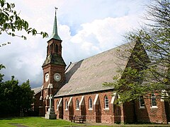
 St Stephen's Church, Banks |
|
| Banks shown within Lancashire | |
| Population | 3,792 2001 Census |
| OS grid reference | SD395212 |
| Civil parish | |
| District | |
| Shire county | |
| Region | |
| Country | England |
| Sovereign state | United Kingdom |
| Post town | SOUTHPORT |
| Postcode district | PR9 |
| Dialling code | 01704 |
| Police | Lancashire |
| Fire | Lancashire |
| Ambulance | North West |
| EU Parliament | North West England |
| UK Parliament | |
Banks /ˈbæŋks/ is a large coastal village in Lancashire, England. It lies south of the Ribble estuary and four miles (6 km) north-east of Southport. The village is administered by West Lancashire Borough Council, and by North Meols parish council for parochial matters. It is in the South Ribble parliamentary constituency. According to the 2001 census, the population of Banks was 3,792.
Banks is the largest of the villages in the parish of North Meols on the West Lancashire coastal plain. Like most of them, it was primarily an agricultural community due to the excellent soil, although there was fishing activity for many years. Production of flowers and vegetables is common on the farms surrounding the village; however the proximity of Southport and Preston have led to Banks' expansion as a dormitory town for commuters.
'Banks' is believed to have been named for the many artificial embankments built in the north of the village to protect it from winter floods from the River Ribble and the tide. The old embankments can be seen when entering Banks at Marsh Road and at the end of George's Lane. However, these embankments became redundant when the River Ribble retreated in the 1900s and larger ones are in place further north creating more farmland. Local people refer to the village as Bonks /ˈbɒŋks/; retained from the Middle English pronunciation.
...
Wikipedia

