Ballens
| Ballens | ||
|---|---|---|

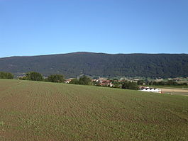
Ballens village
|
||
|
||
| Coordinates: 46°33′N 06°22′E / 46.550°N 6.367°ECoordinates: 46°33′N 06°22′E / 46.550°N 6.367°E | ||
| Country | Switzerland | |
| Canton | Vaud | |
| District | Morges | |
| Government | ||
| • Mayor | Syndic | |
| Area | ||
| • Total | 8.48 km2 (3.27 sq mi) | |
| Elevation | 707 m (2,320 ft) | |
| Population (Dec 2015) | ||
| • Total | 506 | |
| • Density | 60/km2 (150/sq mi) | |
| Postal code | 1144 | |
| SFOS number | 5423 | |
| Surrounded by | Apples, Berolle, Bière, Mollens, Yens | |
| Website |
www Profile (French), SFSO statistics |
|
Ballens is a municipality in the district of Morges in the canton of Vaud in Switzerland.
A tumulus from the Hallstatt time period was found near Ballens.
The first record of Ballens is from 1139 under the name Barlens. In 1453 the spelling Balens appeared. In the Middle Ages Ballens was the center of a small dominion which was under the control of the Romainmôtier monastery and the lords of Aubonne. After the capture of Vaud by Bern in 1536 Ballens shared in the fate of Aubonne and in 1701 it became part of the district of Aubonne. After the collapse of the Ancien régime the village belonged to the canton of Léman from 1798 to 1803 during the Helvetic Republic. It finally became a part of the canton of Vaud as a part of a treaty. In 1798 Ballens was assigned to the district of Morges, and in 1803 it became part of the district of Aubonne.
Ballens is located at 707 m (2,320 ft) above mean sea level (AMSL), 11 km (6.84 mi) northwest of the city of Morges (as the crow flies). It is a scattered village, spread out over a knoll on a plateau at the foot of the Jura Mountains.
Ballens has an area, as of 2009[update], of 8.48 square kilometers (3.27 sq mi). Of this area, 5.42 km2 (2.09 sq mi) or 63.9% is used for agricultural purposes, while 2.49 km2 (0.96 sq mi) or 29.4% is forested. Of the rest of the land, 0.48 km2 (0.19 sq mi) or 5.7% is settled (buildings or roads), 0.03 km2 (7.4 acres) or 0.4% is either rivers or lakes and 0.06 km2 (15 acres) or 0.7% is unproductive land.
...
Wikipedia


