Balanga, Bataan
| Balanga | ||
|---|---|---|
| Component City | ||
| Lungsod ng Balanga (City of Balanga) | ||
 |
||
|
||
| Nickname(s): Balanga 2020 University Town, Balanga Utown, Learning City | ||
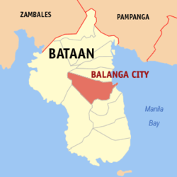
 Location in the province of Bataan |
||
| Location within the Philippines | ||
| Coordinates: 14°41′N 120°32′E / 14.68°N 120.53°ECoordinates: 14°41′N 120°32′E / 14.68°N 120.53°E | ||
| Country | Philippines | |
| Region | Central Luzon (Region III) | |
| Province | Bataan | |
| District | 2nd District | |
| Founded | 1712 | |
| Cityhood | December 30, 2000 | |
| Barangays | 25 | |
| Government | ||
| • Representative, 2nd Congressional District | Jose Enrique S. Garcia III (National Unity) | |
| • Governor | Albert Raymond S. Garcia (National Unity) | |
| • Mayor | Francis S. Garcia (National Unity) | |
| • Vice Mayor | ViancaLita V. Gozon (National Unity) | |
| Area | ||
| • Total | 111.63 km2 (43.10 sq mi) | |
| Population (2015 census) | ||
| • Total | 96,061 | |
| • Density | 860/km2 (2,200/sq mi) | |
| Demonym(s) | Balangueño, Balangueña | |
| Time zone | PHT (UTC+8) | |
| ZIP code | 2100 | |
| Dialing code | +63 (0)47 | |
| Income class | 4th class component city | |
| Website | www |
|
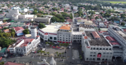
Balanga, officially the City of Balanga (Filipino: Lungsod ng Balanga; Kapampangan: Lakanbalen ning Balanga) or Balanga City, abbreviated as COB, is a fourth classcomponent city and capital of the province of Bataan in the Central Luzon region of the Philippines. According to the 2015 census, it has a population of 96,061 people.
Balanga City is primarily a residential-agricultural city. It has a total land area of 11,163 hectares (8.13% of Bataan).
Balanga, the capital of Bataan, was formerly a visita of Abucay before it was established as a mission of the Dominican Order in the Provincial Chapter of April 21, 1714 and later declared a vicariate on April 18, 1739, under the patronage of Saint Joseph. Upon the establishment of Bataan as a separate province in 1754, Balanga was made its capital by General Pedro Manuel Arandia due to its favorable location, at the heart of the new territorial jurisdiction.
The word Balanga originates from the Kapampangan word "balañga" (clay pot, or "banga" in Tagalog), which the town used to produce and which was among the best that can be found in the country.
On December 30, 2000, Balanga was inaugurated as a City by the Republic Act 8984 authored by Congressman Enrique "Tet" Garcia.
The city has extended its urban fringe to west of Roman Superhighway and a new growth center in Barangay Tuyo has been delineated in the Comprehensive Land Use Plan. During the past years, the city saw a high record of residential growth. The consequent expansion of the physical limits of the urban core as well as the expected large increases in population, and its attractiveness to commercial and employment activities, the City Government of Balanga decided to undertake a Master Planning exercise and to propose various developmental projects that would establish Balanga as a well-planned community with quality and character that is innovative and special, although this is currently hindered by an unreliable electricity supply.
The population of Balanga in the 2015 census was 96,061 people, with a density of 860 inhabitants per square kilometre or 2,200 inhabitants per square mile.
Pursuant to the Local government in the Philippines", the political seat of the municipal government is located at the City Hall. In the History of the Philippines (1521–1898), the Gobernadorcillo is the Chief Executive who holds office in the Presidencia. During the American rule (1898–1946) (History of the Philippines (1898-1946)), the elected Mayor and local officials, including the appointed ones hold office at the Municipal Town or City Hall. The legislative and executive departments perform their functions in the Sangguniang Panglungsod (Session Hall) and the Regional and Metropolitan Trial Courts, respectively, and are located in the second floor of the City Hall and in the Halls of Justice.
...
Wikipedia


