Baixada Maranhense Environmental Protection Area
| Baixada Maranhense Environmental Protection Area | |
|---|---|
| Área de Proteção Ambiental da Baixada Maranhense | |
|
IUCN category VI (protected area with sustainable use of natural resources)
|
|

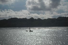
Fishers
|
|
| Nearest city | São Luís, Maranhão |
| Coordinates | 2°50′31″S 44°48′50″W / 2.842°S 44.814°WCoordinates: 2°50′31″S 44°48′50″W / 2.842°S 44.814°W |
| Area | 1,775,035.6 hectares (4,386,208 acres) |
| Designation | Environmental protection area |
| Created | 11 June 1991 |
| Administrator | Secretaria de Estado de Meio Ambiente e Recursos Naturais |
The Baixada Maranhense Environmental Protection Area (Portuguese: Área de Proteção Ambiental da Baixada Maranhense) is an environmental protection area in the state of Maranhão, Brazil. It includes large areas of wetlands, and was designated a Ramsar site in 2000. The traditional population lives in the area, but human activities are regulated in an effort to preserve the environment.
The Baixada Maranhense Environmental Protection Area has an area of 1,775,035.6 hectares (4,386,208 acres) in 32 municipalities of the state of Maranhão. These are Alcântara, Altamira do Maranhão, Anajatuba, Arari, Bacabal, Bacabeira, Bacurituba, Bela Vista do Maranhão, Bequimão, Bom Jardim, Cajapió, Cajari, Cedral, Central do Maranhão, Conceição do Lago-Açu, Guimarães, Igarapé do Meio, Lago Verde, Matinha, Matões do Norte, Mirinzal, Monção, Olho d'Água das Cunhãs, Olinda Nova do Maranhão, Palmeirândia, Pedro do Rosário, Penalva, Peri Mirim, Pindaré-Mirim, Pinheiro, Pio XII, Porto Rico do Maranhão, Presidente Sarney, Santa Helena, Santa Inês, Santa Rita, Satubinha, Serrano do Maranhão, São Bento, São João Batista, São Luís, São Mateus do Maranhão, São Vicente Ferrer, Turiaçu, Turilândia, Viana, Vitorino Freire, and Vitória do Mearim. The traditional population includes indigenous people and some remnants of quilombo communities. The families fish, cultivate rice and breed buffaloes.
...
Wikipedia

