Bago Division
|
Bago Region ပဲခူးတိုင်းဒေသကြီး |
|||
|---|---|---|---|
| Division | |||
| Myanma transcription(s) | |||
| • Burmese | pai: ku: tuing: desa. kri: | ||
|
|||
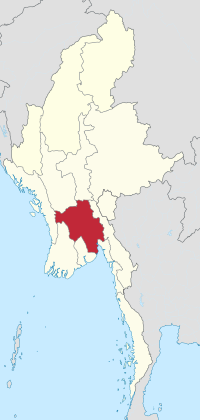
 Location of Bago Region in Myanmar |
|||
| Coordinates: 18°15′N 96°0′E / 18.250°N 96.000°ECoordinates: 18°15′N 96°0′E / 18.250°N 96.000°E | |||
| Country |
|
||
| Region | Lower | ||
| Capital | Bago | ||
| Government | |||
| • Chief Minister | Win Thein (NLD) | ||
| • Cabinet | Bago Region Government | ||
| • Legislature | Bago Region Hluttaw | ||
| Area | |||
| • Total | 39,402.3 km2 (15,213.3 sq mi) | ||
| Area rank | 6th | ||
| Population (2014) | |||
| • Total | 4,867,373 | ||
| • Rank | 6th | ||
| • Density | 120/km2 (320/sq mi) | ||
| Demographics | |||
| • Ethnicities | Bamar, Kayin, Mon, Shan, Indians, Chinese | ||
| • Religions | Buddhism, Islam, Christianity, Hinduism | ||
| Time zone | MST (UTC+06:30) | ||
| Website | bagoregion |
||
Bago Region (Burmese: ပဲခူးတိုင်းဒေသကြီး, pronounced: [bəɡó táɪɴ dèθa̰ dʑí]; formerly Pegu Division and Bago Division) is an administrative region of Myanmar, located in the southern central part of the country. It is bordered by Magway Region and Mandalay Region to the north; Kayin State, Mon State and the Gulf of Martaban to the east; Yangon Region to the south and Ayeyarwady Region and Rakhine State to the west. It is located between 46°45'N and 19°20'N and 94°35'E and 97°10'E.
According to legend, two Mon princes from Thaton founded the city of Bago in 573 AD. They saw a female goose standing on the back of a male goose on an island in a huge lake. Believing this was an auspicious omen, the princes built a city called Hanthawady (Pali: Hamsavati) on the edge of the lake.
The earliest mention of this city in history is by the Arab geographer Ibn Khudadhbin around 850 AD. At the time, the Mon capital had shifted to Thanton. The Bamar from Bagan ruled the area in 1056. After the collapse of Bagan to the Mongols in 1287, the Mon regained their independence.
From 1369–1539, Hanthawady was the capital of the Hanthawaddy Kingdom, which covered all of what is now lower Burma. The area came under Burman control again in 1539, when it was annexed by King Tabinshwehti of Kingdom of Taungoo. The kings of Taungoo made Bago their royal capital from 1539–1599, and used it as a base for their repeated invasions of . As a major seaport, the city was frequently visited by Europeans, who commented on its magnificence. The Burmese capital was relocated to Ava in 1634. In 1740, the Mon revolted and briefly regained their independence, but Burmese King Alaungpaya sacked and completely destroyed the city (along with Mon independence) in 1757.
...
Wikipedia


