Ayr (UK Parliament constituency)
| Ayr | |
|---|---|
| Former County constituency for the House of Commons |
|

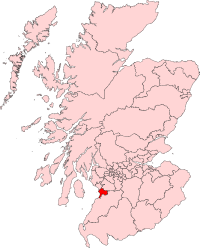
Boundary of Ayr in Scotland for the 1997 general election.
|
|
| Subdivisions of Scotland | Ayrshire |
| 1950–2005 | |
| Number of members | One |
| Replaced by |
Ayr, Carrick & Cumnock Central Ayrshire |
| Created from |
Ayr District of Burghs Kilmarnock South Ayrshire |
Ayr was a county constituency of the House of Commons of the Parliament of the United Kingdom from 1950 to 2005. It elected one Member of Parliament (MP) by the first-past-the-post system of election.
The constituency was created by merging the Ayr burgh and Prestwick burgh components of the Ayr District of Burghs constituency with parts of the South Ayrshire and Kilmarnock constituencies.
1950 to 1974: The civil parishes of Ayr, Prestwick, Tarbolton and Symington.
1974 to 1983: The civil parishes of Ayr (except rural area around Ayr Hospital), Prestwick, Tarbolton and Symington.
1983 to 1997: The towns of Ayr (except the council estate of Kincaidston), Prestwick and Troon plus the villages of Dundonald, Loans, Monkton, Tarbolton and Symington.
1997 to 2005: The 1995 South Ayrshire electoral wards of Dundonald; East Kyle; Fort; Lochside and Craigie; Heathfield; Kingscase; Newton; Seafield; St Cuthbert's; St Nicholas; Troon Central; Troon East; Troon West; Wallacetown and Whitletts, covering Dundonald, Loans, Monkton, Prestwick, Symington, Tarbolton, Troon and the north and west of Ayr. This change led to a substantial alteration in the demographic of the constituency with the Labour Party being the prime beneficiaries.
...
Wikipedia
